Summary of Flooding in Phra Nakhon Sri Ayutthaya Province and Chao Praya River Basin during the 2025 Rainy Season

ประเด็นสำคัญ :
- สาเหตุหลักของการเกิดน้ำท่วมบริเวณจังหวัดพระนครศรีอยุธยาเกิดจากการปรับเพิ่มการระบายน้ำของเขื่อนเจ้าพระยา
- เขื่อนสิริกิติ์มีปริมาณน้ำกักเก็บมากเกินไป ประกอบกับมีฝนที่ตกหนักบริเวณลุ่มน้ำน่าน ทำให้มีน้ำไหลลงเขื่อนมาก ปริมาณน้ำไหลลงเขื่อนรายวันทุบสถิติมากกว่าปี 2554
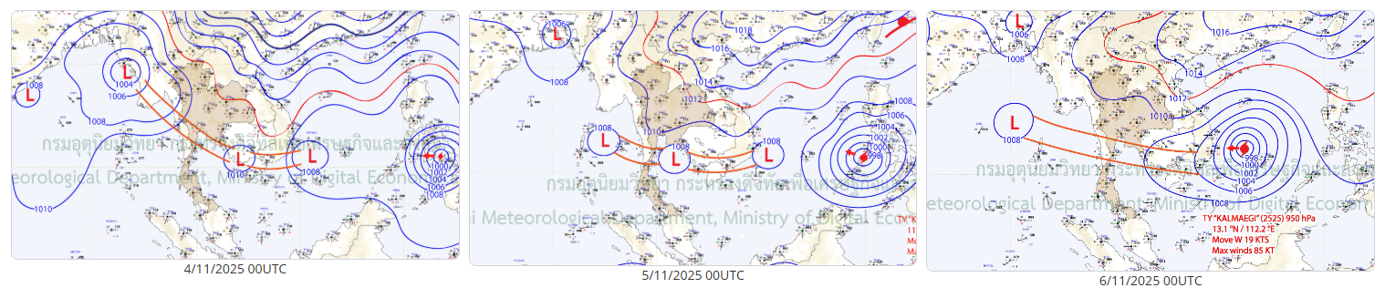
- มีพายุถึง 8 ลูกที่ส่งผลต่อภาคเหนือและภาคกลาง โดยเฉพาะพายุคัลแมกีที่เข้ามาในเดือนพฤศจิกายน ซึ่งถือเป็นเหตุการณ์ที่เกิดขึ้นไม่บ่อยนัก เนื่องจากเป็นช่วงที่สิ้นสุดฤดูฝนไปแล้ว
- การระบายน้ำแบบแนวดิ่งผ่านแม่น้ำเจ้าพระยามุ่งลงสู่อ่าวไทยโดยตรง แต่ต้องป้องกันเมืองหลวง ทำให้มวลน้ำถูกชะลอและเกิดการท่วมขังอยู่บริเวณจังหวัดพระนครศรีอยุธยา ที่ถูกกำหนดให้เป็นพื้นที่รับน้ำ
- พื้นที่ทุ่งรับน้ำมักถูกเลือกเป็นลำดับสุดท้าย กรณีมีปริมาณน้ำมากถึงเกณฑ์เท่านั้นจึงจะเริ่มระบายเข้าสู่ทุ่งรับน้ำได้ ซึ่งในปี 2568 เริ่มเปิดรับน้ำเข้าทุ่งในเดือนตุลาคม ซึ่งถือว่าช้าเกินไป
- เดือนพฤศจิกายนไปจนถึงสิ้นปี จุดวัดน้ำรวมถึงประตูระบายน้ำสำคัญ ยังคงมีน้ำไหลผ่านค่อนข้างมาก และส่วนใหญ่มากกว่าปี 2538 2549 และ 2554 (ปีที่ลุ่มเจ้าพระยาเกิดอุทกภัยรุนแรง) หากเทียบกับข้อมูลในช่วงเวลาเดียวกัน ซึ่งถือเป็นสถานการณ์ที่ผิดไปจากที่เคยเป็น
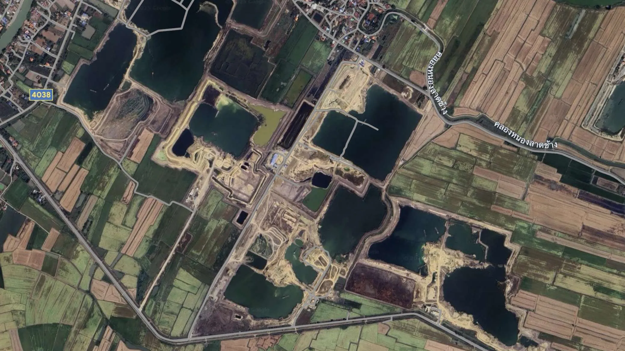
- การขยายตัวของบ่อทรายและโครงการก่อสร้างในทุ่งบางบาล ลดศักยภาพในการรับน้ำ และสร้างปัญหาสิ่งแวดล้อมซ้ำเติมชุมชน
- ทางระบายน้ำเข้าไปสู่ทุ่งรับน้ำ เช่น ท่อลอด หรือประตูน้ำต่าง ๆ มีน้อย ทำให้ควบคุมน้ำได้ยาก
Key Points :
- The main cause of flooding in Phra Nakhon Si Ayutthaya Province is the increased water discharge from the Chao Phraya Dam.
- The Sirikit Dam has an excessive amount of stored water, combined with heavy rainfall in the Nan River basin, resulting in a large inflow into the dam. The daily inflow has broken records, exceeding levels seen in 2011.
- As many as eight storms affected the northern and central regions, especially Storm Kalmaegi in November, which is considered unusual since it occurred after the rainy season had already ended.
- Water drainage follows a vertical flow along the Chao Phraya River directly toward the Gulf of Thailand. However, efforts to protect the capital slow down the water mass, causing it to accumulate and flood areas in Phra Nakhon Si Ayutthaya, which has been designated as a flood retention area.
- Flood retention fields are usually used as a last resort. Only when water volume reaches a certain threshold is water diverted into these areas. In 2025, water diversion into the fields began in October, which is considered too late.
- From November through the end of the year, water monitoring stations and key sluice gates still recorded relatively high-water flow, mostly exceeding levels seen in 1995, 2006, and 2011 (years of severe flooding in the Chao Phraya basin) when compared over the same period. This indicates an unusual situation.
- The expansion of sand pits and construction projects in the Bang Ban fields has reduced water retention capacity and worsened environmental problems for local communities.
- There are limited channels for directing water into retention areas, such as culverts and water gates, making water management difficult.
แม้ภาพเหตุการณ์น้ำท่วมโดยรวมของปี 2568 ในพื้นที่ภาคเหนือและภาคกลางจะดูรุนแรงน้อยกว่าปี 2554 แต่กลับมีบางข้อเท็จจริงที่ทำให้เห็นว่าความรุนแรงที่เกิดขึ้นนั้นมีมากกว่า ทั้งปริมาณมวลน้ำ พื้นที่ถูกน้ำท่วม ความยาวนานของการเกิดน้ำท่วม รวมถึงความเสียหายที่เกิด ซึ่งทั้งหมดที่กล่าวมานั้น เกิดกระจุกตัวอยู่บริเวณจังหวัดพระนครศรีอยุธยา
สำนักงานป้องกันและบรรเทาสาธารณภัยจังหวัดพระนครศรีอยุธยา ได้รายงานสถานการณ์อุทกภัยเมื่อวันที่ 24 พฤศจิกายน 2568 โดยอำเภอที่มีบ้านเรือนประชาชนได้รับผลกระทบจากอุทกภัย ประกอบด้วย อ.เสนา อ.ผักไห่ อ.บางบาล อ.บางไทร อ.พระนครศรีอยุธยา อ.บางปะอิน อ.บางปะหัน อ.บางซ้าย อ.บ้านแพรก อ.ลาดบัวหลวง อ.มหาราช อ.นครหลวง รวมทั้งสิ้น 12 อำเภอ 145 ตำบล 946 หมู่บ้าน 65,238 ครัวเรือน มีผู้เสียชีวิตจำนวน 20 ราย ที่ อ.เสนา อ.ผักไห่ อ.บางบาล อ.บางไทร และ อ.พระนครศรีอยุธยา มีสิ่งปลูกสร้างที่ได้รับความเสียหาย ประกอบด้วย มัสยิด 2 แห่ง ถนนในหมู่บ้าน 58 สาย สถานที่ราชการ 8 แห่ง โรงเรียน 33 แห่ง วัด 38 แห่ง
ทั้งนี้ ข้อมูลจากภาพถ่ายดาวเทียมตลอดช่วงฤดูฝน ชี้ให้เห็นว่าจังหวัดพระนครศรีอยุธยามีพื้นที่ถูกน้ำท่วมเกือบ 800,000 ไร่ เดือนพฤศจิกายนเป็นเดือนที่มีพื้นที่ถูกน้ำท่วมมากที่สุดถึง 781,921 ไร่ โดยอำเภอที่ตั้งอยู่ริมน้ำได้รับผลกระทบค่อนข้างหนัก ได้แก่ อ.เสนา อ.ผักไห่ อ.บางบาล อ.บางไทร อ.บางปะอิน และ อ.พระนครศรีอยุธยา ที่ได้รับผลกระทบหนักเนื่องจากมีน้ำท่วมยาวนานต่อเนื่องหลายเดือน โดยเฉพาะพื้นที่ลุ่มต่ำริมน้ำบริเวณอำเภอเสนาที่เริ่มมีน้ำล้นตลิ่งเข้าท่วมตั้งแต่เดือนพฤษภาคม 2568
Although the overall flooding situation in 2025 in the northern and central regions appeared less severe than in 2011, several facts indicate that the actual severity was greater. These include the volume of water, the extent of flooded areas, the duration of flooding, and the resulting damage. All these mentioned were concentrated in Phra Nakhon Si Ayutthaya Province.
The Office for Prevention and Mitigation Phra Nakhon Sri Ayutthaya reported the flood situation on 24 November 2025. The districts affected, where residential areas were impacted by flooding, include Sena, Phak Hai, Bang Ban, Bang Sai, Phra Nakhon Si Ayutthaya, Bang Pa-in, Bang Pahan, Bang Sai, Ban Phraek, Lat Bua Luang, Maha Rat, and Nakhon Luang. In total, the flooding affected 12 districts, 145 subdistricts, 946 villages, and 65,238 households. There were 20 fatalities, reported in Sena, Phak Hai, Bang Ban, Bang Sai, and Phra Nakhon Si Ayutthaya districts. Damaged structures include 2 mosques, 58 village roads, 8 government offices, 33 schools, and 38 temples.
Satellite imagery data throughout the rainy season indicates that Phra Nakhon Si Ayutthaya Province experienced flooding over nearly 800,000 rai of land. November recorded the highest flooded area, reaching 781,921 rai. Districts located along the river were particularly heavily affected, including Sena, Phak Hai, Bang Ban, Bang Sai, Bang Pa-in, and Phra Nakhon Si Ayutthaya. These areas suffered severe impacts due to prolonged flooding that lasted for several consecutive months. Low-lying riverside areas, especially in Sena District, began experiencing river overflow and flooding as early as May 2025.

ข้อเท็จจริงและสาเหตุของการเกิดอุทกภัย
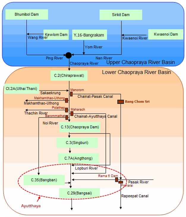
1. การระบายน้ำจากเขื่อนเจ้าพระยา จ.ชัยนาท
สาเหตุหลักของการเกิดน้ำท่วมบริเวณจังหวัดพระนครศรีอยุธยาเกิดจากการปรับเพิ่มการระบายน้ำของเขื่อนเจ้าพระยา ที่ อ.สรรพยา จ.ชัยนาท ลงสู่พื้นที่ท้ายเขื่อนอย่างต่อเนื่องเพื่อบริหารจัดการน้ำในลุ่มเจ้าพระยาตอนบน ทำให้แม่น้ำเจ้าพระยา แม่น้ำน้อย และคลองสาขาต่าง ๆ เกิดน้ำเอ่อล้นตลิ่งเข้าท่วมในหลายพื้นที่ ทั้งนี้เขื่อนเจ้าพระยาเริ่มระบายน้ำมากกว่า 700 ลูกบาศก์เมตรต่อวินาที ตั้งแต่ 28 พฤษภาคม 2568 ซึ่งเป็นอัตราการระบายที่ส่งผลทำให้เกิดน้ำท่วมน้ำล้นตลิ่งในพื้นที่ลุ่มต่ำริมน้ำ ซึ่งจากตารางเกณฑ์การระบายน้ำของกรมชลประทาน เมื่อระบายน้ำตั้งแต่ 700 ลูกบาศก์เมตรต่อวินาทีขึ้นไปจะทำให้เกิดน้ำล้นตลิ่งบริเวณคลองโผงเผง คลองบางบาลและชุมชนแม่น้ำน้อยบริเวณ ต.หัวเวียง อ.เสนา ต.ลาดชิด ต.ท่าดินแดง อ.ผักไห่ จ.พระนครศรีอยุธยา
ต่อมาในช่วงวันที่ 13 กันยายน 2568 มีการระบายน้ำมากกว่า 2,000 ลูกบาศก์เมตรต่อวินาที และเพิ่มขึ้นต่อเนื่องเป็นมากกว่า 2,200 ลูกบาศก์เมตรต่อวินาทีในช่วงวันที่ 18-25 กันยายน 2568 และช่วงวันที่ 29 กันยายน – 2 ตุลาคม 2568 หลังจากนั้นได้ระบายเพิ่มขึ้นมากกว่า 4,000 ลูกบาศก์เมตรต่อวินาทีในช่วงวันที่ 3-8 ตุลาคม 2568 และ 17-27 ตุลาคม 2568
ซึ่งถึงแม้จะเข้าสู่เดือนพฤศจิกายนแล้ว แต่เขื่อนเจ้าพระยากลับยังคงระบายน้ำเพิ่มขึ้นค่อนข้างมาก และมีการระบายมากกว่าศักยภาพการระบายสูงสุดของประตูระบายน้ำในช่วงวันที่ 9-17 พฤศจิกายน 2568 โดยมีอัตราการระบายสูงสุดที่ 2,900 ลูกบาศก์เมตรต่อวินาที ในวันที่ 11 พฤศจิกายน 2568 อีกทั้งตั้งแต่วันที่ 10 พฤศจิกายน ถึงสิ้นปี ปริมาณน้ำที่ระบายออกไปในแต่ละวันเป็นปริมาณน้ำระบายมากกว่าปี 2538 2549 และ 2554 อยู่ค่อนข้างมาก ซึ่งถือเป็นการระบายน้ำที่ค่อนข้างผิดปกติกจากที่เคยเป็น
Facts and Causes of Flooding
1. Water Discharge from Chao Phraya Dam, Chainat Province
The primary cause of flooding in Phra Nakhon Si Ayutthaya Province was the continuous increase in water discharge from the Chao Phraya Dam in Sapphaya District, Chainat Province, as part of water management efforts in the upper Chao Phraya River basin. This resulted in overflow from the Chao Phraya River, Noi River, and various canals, inundating many downstream areas.
The dam began releasing water at a rate exceeding 700 cubic meters per second (cms) on 28 May 2025. This level of discharge is sufficient to cause riverbank overflow and flooding in low-lying riverside areas. According to the Royal Irrigation Department’s discharge criteria, releases of 700 cms or more can lead to overflow in areas such as Khlong Phong Pheng, Khlong Bang Ban, and communities along the Noi River, including Hua Wiang Subdistrict (Sena District), Lat Chit Subdistrict, and Tha Din Daeng Subdistrict (Phak Hai District) in Phra Nakhon Sri Ayutthaya.
Subsequently, on 13 September 2025, discharge levels exceeded 2,000 cms, increasing further to over 2,200 cms during 18–25 September and 29 September – 2 October 2025. The discharge then rose significantly to over 4,000 cms during 3–8 October and again during 17–27 October 2025.
Despite entering November, the dam continued to release high volumes of water. Between 9–17 November 2025, discharge rates exceeded the maximum capacity of downstream sluice gates, with a peak of 2,900 cms on 11 November 2025.
Furthermore, from 10 November through the end of the year, daily discharge volumes were consistently higher than those recorded in 1995, 2006, and 2011, indicating an unusually high and atypical level of water release compared to historical patterns.


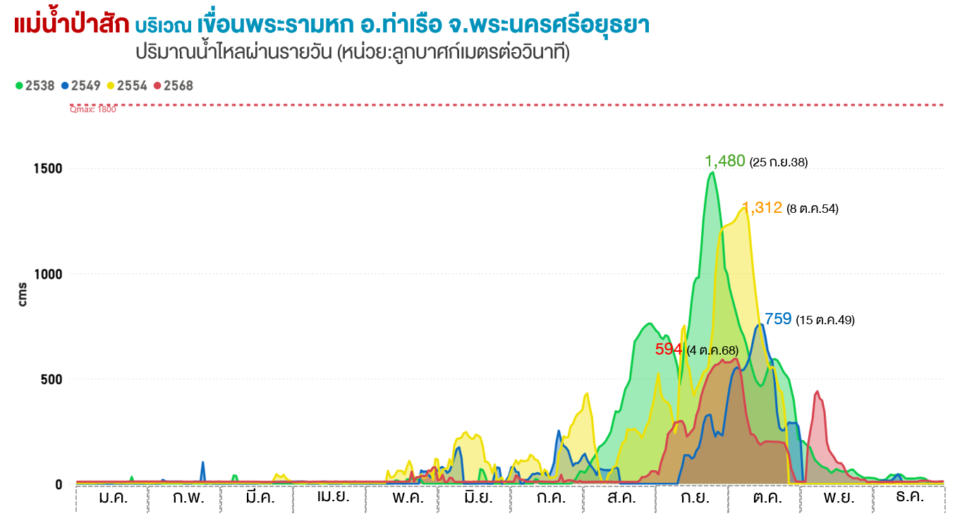
นอกจากนี้ เขื่อนพระรามหก อ.ท่าเรือ จ.พระนครศรีอยุธยา มีการระบายน้ำมากผิดปกติ ในช่วงปลายเดือนพฤศจิกายน 2568 เช่นกัน และเป็นปริมาณน้ำที่ระบายมากกว่าปี 2538 2549 2554 อยู่ค่อนข้างมาก หากเทียบกับข้อมูลในช่วงเวลาเดียวกัน ซึ่งการระบายน้ำของเขื่อนจะทำให้มวลน้ำไหลผ่านแม่น้ำป่าสักมุ่งตรงเข้าสู่จังหวัดพระนครศรีอยุธยา
In addition, the Rama VI Dam in Tha Ruea District, Phra Nakhon Si Ayutthaya Province, also recorded unusually high-water discharge during late November 2025. The volume of discharged water was significantly higher than that observed during the same period in 1995, 2006, and 2011. This increased discharge caused large volumes of water to flow along the Pa Sak River, directly into Phra Nakhon Si Ayutthaya Province.
อีกทั้ง ปตร.บรมธาตุ อ.เมืองชัยนาท ได้มีการเพิ่มอัตราการระบายน้ำในช่วงต้นเดือนจนถึงกลางเดือนพฤศจิกายน 2568 เช่นเดียวกัน ซึ่งการผันน้ำจากแม่น้ำเจ้าพระยาออกสู่แม่น้ำน้อยผ่าน ปตร.บรมธาตุ มวลน้ำจะวกกลับเข้าสู่จังหวัดพระนครศรีอยุธยา ซึ่งในช่วงเวลาดังกล่าวยังคงมีสถานการณ์อุทกภัยในพื้นที่
In addition, the Borommathat Water Control Gate in Mueang Chainat District also increased its discharge rates from early to mid-November 2025. The diversion of water from the Chao Phraya River into the Noi River through this gate caused the water mass to flow back into Phra Nakhon Si Ayutthaya Province. During this period, flooding conditions in the area were still ongoing.

2. การระบายน้ำแบบแนวดิ่ง
การระบายน้ำแบบแนวดิ่งผ่านแม่น้ำเจ้าพระยามุ่งลงสู่อ่าวไทยโดยตรง เป็นวิธีการที่ช่วยลดปริมาณน้ำจากพื้นที่ตอนบนของลุ่มน้ำได้อย่างรวดเร็ว แต่ในทางกลับกัน ความจำเป็นที่จะต้องป้องกันกรุงเทพมหานครและปริมณฑลไม่ให้ถูกน้ำท่วม ทำให้มวลน้ำถูกชะลอและเกิดการท่วมขังอยู่บริเวณจังหวัดพระนครศรีอยุธยา ที่ถูกกำหนดให้เป็นพื้นที่รับน้ำเพื่อป้องกันเมืองหลวง แทนที่จะกระจายน้ำเข้าทุ่งแก้มลิงเพื่อช่วยลดความเดือดร้อนที่เกิดขึ้น
2. Vertical Water Drainage
Vertical drainage, in which water is conveyed directly along the Chao Phraya River toward the Gulf of Thailand, is an approach that helps rapidly reduce water volume from the upper basin. However, the need to protect Bangkok Metropolitan Area and its vicinity from flooding resulted in water being slowed down and retained in Phra Nakhon Si Ayutthaya Province. As a result, Ayutthaya was designated as a flood retention area to safeguard the capital, rather than distributing water into designated “monkey cheek” retention fields, which could have helped alleviate the impacts on affected communities.
3. การผันน้ำเข้าทุ่งรับน้ำ
พื้นที่ทุ่งรับน้ำหรือพื้นที่หน่วงน้ำมักถูกเลือกเป็นลำดับสุดท้าย กรณีมีปริมาณน้ำมากถึงเกณฑ์เท่านั้นจึงจะเริ่มระบายเข้าสู่ทุ่งรับน้ำได้ ซึ่งในปี 2568 เริ่มเปิดรับน้ำเข้าทุ่งในเดือนตุลาคม ซึ่งถือว่าช้าเกินไป นอกจากนี้การระบายน้ำเข้าทุ่งจะต้องรอให้เกษตรกรเก็บเกี่ยวเสร็จ ซึ่งการระบายน้ำเข้าทุ่งที่ทำได้ช้าก็จะยิ่งทำให้บ้านเรือนบริเวณริมน้ำได้รับความเสียหายมากยิ่งขึ้น อีกอย่างหนึ่งคือการพิจารณาจากเงื่อนไขที่ว่าจะระบายน้ำเข้าทุ่งได้ เขื่อนเจ้าพระยาจะต้องระบายน้ำตั้งแต่ 2,500 ลบ.ม./วินาที ขึ้นไป ซึ่งด้วยเงื่อนไขนี้ ประชาชนที่อาศัยอยู่ริมน้ำของ อ.เสนา อ.บางบาล และ อ.ผักไห่ มักจะได้รับผลกระทบมาแล้วอย่างน้อยหนึ่งถึงสองเดือน นอกจากนี้ปัญหาเรื่องทางระบายน้ำเข้าไปสู่ทุ่งรับน้ำ เช่น ท่อลอด หรือประตูน้ำต่าง ๆ ที่มีอยู่น้อย ส่งผลให้ควบคุมน้ำได้ยาก ประกอบกับรัฐบาลไม่มีมาตรการเยียวยาเกษตรกรที่ไร่นาถูกระบายน้ำเข้าไป ดังนั้น ค่าใช้จ่ายในการสูบน้ำออกจึงตกเป็นภาระของเกษตรกร ซึ่งการระบายน้ำระหว่างชุมชนและทุ่งรับน้ำที่ยังไม่สามารถจัดการได้อย่างเต็มประสิทธิภาพ ทำให้ชาวบ้านริมแม่น้ำต้องแบกรับภาระน้ำท่วมสูงซ้ำซาก ระบบการระบายน้ำและการเปิด–ปิดประตูน้ำที่ไม่สอดประสานกันอย่างเหมาะสม ส่งผลให้บางพื้นที่ถูกน้ำท่วมหนักเกินจำเป็น
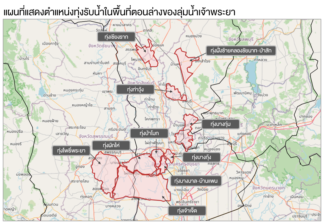
ทั้งนี้ พื้นที่ตอนล่างของลุ่มน้ำเจ้าพระยา มีทุ่งรับน้ำทั้งหมด 10 ทุ่ง ซึ่งในช่วงที่เกิดเหตุการณ์อุทกภัยบริเวณจังหวัดพระนครศรีอยุธยา แต่ละทุ่งมีปริมาณน้ำเพิ่มเข้าไปในทุ่งแตกต่างกัน ดังนี้
• ทุ่งเชียงราก จ.ชัยนาท ซึ่งเป็นทุ่งที่อยู่บนสุดเมื่อเทียบกับทุ่งอื่น ๆ ทุ่งนี้มีน้ำเพิ่มเข้าไปในทุ่งค่อนข้างมากในช่วงเดือนตุลาคม 2568 ต่อเนื่องไปจนถึงช่วงปลายเดือนพฤศจิกายน 2568 หลังจากนั้นปริมาณน้ำในทุ่งจึงค่อย ๆ ลดลงอย่างต่อเนื่อง ทั้งนี้ได้เกิดเหตุการณ์ปริมาณน้ำเกินศักยภาพการรับน้ำของทุ่ง (น้ำล้นทุ่ง) 26 วัน ช่วงแรกเกิดขึ้น 11 วัน ระหว่างวันที่ 17-27 ตุลาคม 2568 และช่วงที่ 2 เกิดขึ้นระหว่างวันที่ 12-26 พฤศจิกายน 2568 รวม 15 วัน
• ทุ่งบางกุ่ม บริเวณ จ.สระบุรี และ จ.พระนครศรีอยุธยา ทุ่งนี้มีน้ำเพิ่มเข้าไปในทุ่งตั้งแต่เดือนตุลาคม 2568 และเพิ่มขึ้นค่อนข้างมากในช่วงเดือนพฤศจิกายน แต่เป็นเพียงระยะเวลาสั้น ๆ เท่านั้น และเป็นการรับน้ำที่ยังไม่เต็มศักยภาพของทุ่ง
• ทุ่งป่าโมก จ.พระนครศรีอยุธยา ทุ่งนี้มีน้ำไหลเข้าทุ่งเพิ่มขึ้นมากในช่วงเดือนตุลาคม 2568 ต่อเนื่องไปจนถึงเดือนธันวาคม 2568 แต่ยังคงเป็นการรับน้ำที่ยังไม่เต็มศักยภาพการกักเก็บน้ำของทุ่ง
• ทุ่งผักไห่ จ.พระนครศรีอยุธยา มีน้ำเข้าไปในทุ่งค่อนข้างมากตั้งแต่เดือนตุลาคม 2568 และเกินศักยภาพการรับน้ำของทุ่งไปมากเป็นเท่าตัว ทำให้เกิดน้ำล้นทุ่งไปมากและเกิดขึ้นยาวนานถึง 83 วัน ระหว่างวันที่ 11 ตุลาคม 2568 ถึง 1 มกราคม 2569
ทุ่งโพธิ์พระยา จ.สุพรรณบุรี เริ่มมีน้ำเข้าทุ่งค่อนข้างมากตั้งแต่เดือนพฤศจิกายน 2568 ต่อเนื่องไปจนถึงสิ้นปี และปริมาณน้ำมีมากเกินความจุของทุ่งตั้งแต่วันที่ 20 พฤศจิกายน ถึง 28 ธันวาคม 2568 รวมระยะเวลา 36 วัน
• ทุ่งบางกุ้ง จ.พระนครศรีอยุธยา มีน้ำเข้าไปในทุ่งเพิ่มขึ้นอย่างรวดเร็วในเดือนตุลาคม 2568 และเริ่มเกินศักยภาพการรับน้ำของทุ่งตั้งแต่วันที่ 20 ตุลาคม 2568 ถึงวันที่ 24 ธันวาคม 2568 รวมระยะเวลาถึง 66 วัน
• ทุ่งเจ้าเจ็ด จ.พระนครศรีอยุธยา มีน้ำเข้าไปในทุ่งเพิ่มขึ้นอย่างมากในเดือนตุลาคม 2568 แล้วลดลงเล็กน้อย ก่อนที่จะเพิ่มขึ้นมากอีกครั้ง จนเกินความจุของทุ่งตั้งแต่วันที่ 17 พฤศจิกายน 2568 ถึง 18 ธันวาคม 2568 รวม 32 วัน
ส่วนทุ่งที่รับน้ำเข้าทุ่งไปได้ค่อนข้างน้อย ปริมาณน้ำยังต่ำกว่าศักยภาพการรับน้ำของทุ่งอยู่ค่อนข้างมาก มีอยู่ 3 ทุ่ง ได้แก่ 1) ทุ่งฝั่งซ้ายคลองชัยนาท-ป่าสัก จ.ลพบุรี 2) ทุ่งท่าวุ้ง จ.ลพบุรี 3) ทุ่งบางบาล-บ้านแพน จ.พระนครศรีอยุธยา
3. Water Diversion into Floodplains
Flood retention areas, or “monkey cheek” zones, are typically used as a last resort and are only activated when water levels reach critical thresholds. In 2025, water diversion into these fields began in October, which was considered too late.
Additionally, diversion into retention fields must wait until farmers complete their harvests. Delays in releasing water into these areas consequently increase damage to riverside residential communities. Another key condition is that the Chao Phraya Dam must discharge at least 2,500 cms before water can be diverted into the fields. Under this condition, residents living along the river in Sena, Bang Ban, and Phak Hai districts are often already affected by flooding for at least one to two months.
Furthermore, limitations in infrastructure—such as the insufficient number of culverts and water gates leading into retention areas—make water management difficult. The lack of government compensation measures for farmers whose fields are intentionally flooded also places the burden of pumping water out on the farmers themselves.
As a result, inefficient coordination between community drainage systems and retention areas, along with poorly synchronized operation of water gates, leads to repeated and severe flooding in riverside communities, with some areas experiencing unnecessarily high levels of inundation.
In the lower Chao Phraya River basin, there are a total of 10 flood retention fields. During the flooding events in Phra Nakhon Si Ayutthaya Province, each of these fields received varying volumes of water, as follows:
• Chiang Rak Floodplain (Chainat Province): As the uppermost flood retention field, it received a substantial volume of water from October 2025 through late November. Water levels then gradually declined. However, the field exceeded its storage capacity (“overflowed”) for a total of 26 days in two periods: 17–27 October 2025 (11 days) and 12–26 November 2025 (15 days).
• Bang Kum Floodplain (Saraburi and Phra Nakhon Si Ayutthaya Provinces): Water began entering the area in October 2025, increasing significantly in November, but only for a short duration and still below the field’s full storage capacity.
• Pa Mok Floodplain (Phra Nakhon Si Ayutthaya Province): Water inflow increased considerably from October through December 2025, but remained below the field’s full storage capacity.
• Phak Hai Floodplain (Phra Nakhon Si Ayutthaya Province): This area received a large volume of water starting in October 2025, exceeding its storage capacity by more than double. Overflow persisted for 83 days, from 11 October 2025 to 1 January 2026.
• Pho Phraya Floodplain (Suphan Buri Province): Significant inflow began in November 2025 and continued through the end of the year. Water exceeded capacity from 20 November to 28 December 2025, totaling 36 days.
• Bang Kung Floodplain (Phra Nakhon Si Ayutthaya Province): Water levels rose rapidly in October 2025, exceeding capacity from 20 October to 24 December 2025, for a total of 66 days.
• Chao Chet Floodplain (Phra Nakhon Si Ayutthaya Province): Water levels increased significantly in October 2025, briefly declined, then rose again and exceeded capacity from 17 November to 18 December 2025, totaling 32 days.
Floodplains with relatively low water intake (below capacity) include three areas: 1) Left Bank of the Chai Nat–Pa Sak Canal Floodplain (Lopburi Province) 2) Tha Wung Floodplain (Lopburi Province) 3) Bang Ban–Ban Paen Floodplain (Phra Nakhon Si Ayutthaya Province)
4. สภาวะอากาศ
4.1 พายุหมุนเขตร้อน
ช่วงฤดูฝปี 2568 บริเวณตอนบนของประเทศไทยรวมถึงลุ่มน้ำเจ้าพระยาได้รับอิทธิพลจากพายุถึง 8 ลูก ซึ่งส่งผลทำให้มีปริมาณฝนเพิ่มขึ้นในหลายพื้นที่
1.พายุไต้ฝุ่น “วิภา” (WIHPA) – ส่งผลกระทบในช่วงปลายเดือนกรกฎาคม 2568
พายุลูกนี้อ่อนกำลังลงเป็นพายุดีเปรสชันและหย่อมความกดอากาศต่ำกำลังแรงบริเวณประเทศลาว และเคลื่อนเข้าปกคลุมบริเวณภาคเหนือตอนบนของไทยและประเทศเมียนมาตอนบนในวันที่ 23 กรกฎาคม 2568
2.พายุไต้ฝุ่น “คาจิกิ” (KAJIKI) – ส่งผลกระทบในช่วงปลายเดือนสิงหาคม 2568
0วันที่ 26 สิงหาคม 2568 พายุลูกนี้ได้อ่อนกำลังลงเป็นพายุดีเปรสชันขณะเคลื่อนตัวอยู่บริเวณประเทศลาว ก่อนสลายตัวเป็นหย่อมความกดอากาศต่ำกำลังแรงเคลื่อนเข้าปกคลุมบริเวณจังหวัดน่านในวันเดียวกัน ก่อนเคลื่อนเข้าปกคลุมตอนบนของประเทศเมียนมาในวันที่ 27 สิงหาคม 2568
3.พายุโซนร้อน “หนองฟ้า” (NONGFA) – ส่งผลกระทบในช่วงปลายเดือนสิงหาคมถึงต้นเดือนกันยายน 2568
วันที่ 30 สิงหาคม 2568 พายุได้เคลื่อนผ่านตอนกลางของประเทศเวียดนามเข้าสู่ประเทศลาวพร้อมอ่อนกำลังลงเป็นพายุดีเปรสชันในช่วงเย็นของวันเดียวกัน จากนั้นได้อ่อนกำลังลงเป็นหย่อมความกดอากาศต่ำเคลื่อนเข้าปกคลุมบริเวณภาคตะวันออกเฉียงเหนือตอนบนและภาคเหนือตอนล่างของไทยในวันที่ 31 สิงหาคม 2568
4.พายุโซนร้อน “ตาปะห์” (TAPAH) – ส่งผลกระทบโดยอ้อมในช่วงต้นเดือนกันยายน 2568
พายุลูกนี้ได้เคลื่อนขึ้นฝั่งบริเวณมณฑลกวางตุ้ง ประเทศจีนก่อนจะสลายตัวไปในวันที่ 8 กันยายน 2568 โดยส่งผลทำให้มรสุมตะวันตกเฉียงใต้ปานกลางที่พัดปกคลุมทะเลอันดามัน ประเทศไทยและอ่าวไทย มีกําลังแรงขึ้นในช่วงวันที่ 7-8 กันยายน 2568
5.พายุไต้ฝุ่น “รากาซา” (RAGASA) – ส่งผลกระทบโดยอ้อมในช่วงปลายเดือนกันยายน 2568
วันที่ 25 กันยายน 2568 พายุได้สลายตัวเป็นหย่อมความกดอากาศต่ำกําลังแรงที่บริเวณประเทศเวียดนาม โดย อิทธิพลของพายุส่งผลทำให้มรสุมตะวันตกเฉียงใต้กําลังปานกลางที่พัดปกคลุมทะเลอันดามัน ประเทศไทยและอ่าวไทยมีกําลังแรงขึ้นซึ่งนำไปสู่ปริมาณฝนที่เพิ่มขึ้นตามไปด้วย
6.พายุไต้ฝุ่น “บัวลอย” (BUALOI) – ส่งผลกระทบในช่วงปลายเดือนกันยายน 2568
วันที่ 29 กันยายน 2568 พายุได้เคลื่อนเข้าสู่ประเทศลาวและอ่อนกําลังลงเป็นหย่อมความกดอากาศต่ำกําลังแรง ก่อนเคลื่อนเข้าปกคลุมบริเวณตอนบนของประเทศลาวและประเทศเมียนมาในวันที่ 30 กันยายน 2568 ซึ่งอิทธิพลของพายุทําให้ภาคเหนือและภาคตะวันออกเฉียงเหนือมีฝนมากขึ้น และมีฝนตกหนักถึงหนักมากในบางพื้นที่
7.พายุไต้ฝุ่น “แมตโม” (MATMO) – ส่งผลกระทบในช่วงต้นเดือนตุลาคม 2568
พายุลูกนี้ได้อ่อนกําลังลงเป็นพายุโซนร้อนในวันที่ 6 ตุลาคม 2568 หลังจากนั้นได้เคลื่อนเข้าปกคลุมบริเวณเมืองหลั่งเซิน ในพื้นที่ตอนบนของประเทศเวียดนาม แล้วอ่อนกำลังลงเป็นหย่อมความกดอากาศต่ำกําลังแรงปกคลุมพื้นที่ดังกล่าว ในวันที่ 7 ตุลาคม 2568 อิทธิพลของพายุลูกนี้ส่งผลทำให้ประเทศไทยมีปริมาณฝนเพิ่มขึ้น
8.พายุไต้ฝุ่น “คัลแมกี” (KALMAEGI) -ส่งผลกระทบในช่วงต้นเดือนพฤศจิกายน 2568
พายุไต้ฝุ่น “คัลแมกี” ได้เคลื่อนเข้าสู่บริเวณ อ.สิรินธร จังหวัดอุบลราชธานี เมื่อวันที่ 7 พฤศจิกายน 2568 ในขณะที่ยังเป็นพายุดีเปรสชัน ซึ่งต่อมาได้อ่อนกำลังลงเป็นหย่อมความกดอากาศต่ำกำลังแรงบริเวณจังหวัดศรีสะเกษ แล้วเคลื่อนตัวต่อเนื่องผ่านภาคตะวันออกเฉียงเหนือ ภาคเหนือและประเทศเมียนมาตามลำดับ
4. Weather Condition
4.1 Storms
During the 2025 rainy season, the upper part of Thailand, including the Chao Phraya River Basin, was affected by a total of storms, resulting in increased rainfall across the several areas:
1. Typhoon “Wipha”– Impact in late July 2025
The storm weakened into a tropical depression and then a strong low-pressure system over Laos, moving to cover upper northern Thailand and northern Myanmar on 23 July 2025.
2. Typhoon “Kajiki”– Impact in late August 2025
On 26 August 2025, the storm weakened into a tropical depression over Laos, then dissipated into a strong low-pressure system affecting Nan Province on the same day, before moving into upper Myanmar on 27 August 2025.
3. Tropical Storm “Nongfa”– Impact from late August to early September 2025
On 30 August 2025, the storm moved across central Vietnam into Laos, weakening into a tropical depression and later into a strong low-pressure system affecting upper northeastern and lower northern Thailand on 31 August 2025.
4. Tropical Storm “Tapah”– Indirect impact in early September 2025
The storm made landfall in Guangdong, China, before dissipating on 8 September 2025. Its influence strengthened the southwest monsoon over the Andaman Sea, Thailand, and the Gulf of Thailand during 7–8 September 2025.
5. Typhoon “Ragasa”– Indirect impact in late September 2025
On 25 September 2025, the storm weakened into a strong low-pressure system over Vietnam, intensifying the southwest monsoon over the Andaman Sea, Thailand, and the Gulf of Thailand, leading to increased rainfall.
6. Typhoon “Bualoi”– Impact in late September 2025
On 29 September 2025, the storm moved into Laos and weakened into a strong low-pressure system, later affecting upper Laos and Myanmar on 30 September 2025, bringing increased rainfall and heavy to very heavy rain in parts of northern and northeastern Thailand.
7. Typhoon “Matmo”– Impact in early October 2025
The storm weakened into a tropical storm on 6 October 2025, then moved into Lang Son, Vietnam, and further weakened into a strong low-pressure system on 7 October 2025, contributing to increased rainfall in Thailand.
8. Typhoon “Kalmaegi”– Impact in early November 2025
The storm entered Sirindhorn District, Ubon Ratchathani Province on 7 November 2025 as a tropical depression, then weakened into a strong low-pressure system over Si Sa Ket Province, continuing to move across northeastern and northern Thailand and into Myanmar.


4.2 หย่อมความกดอากาศต่ำ ลมมรสุมและร่องมรสุม
ช่วงปลายเดือนกรกฎาคม 2568 มีร่องมรุสมพาดผ่านประเทศไทยเป็นระยะ ๆ อีกทั้งมีหย่อมความกดอากาศต่ำปกคลุมบริเวณอ่าวตังเกี๋ยในช่วงสิ้นเดือน ประกอบกับลมมรสุมตะวันตกเฉียงใต้ที่พัดผ่านทะเลอันดามัน ประเทศไทยและอ่าวไทยมี กำลังปานกลาง ซึ่งลักษณะดังกล่าวทำให้ประเทศไทยมีฝนตกเกิดขึ้นในหลายพื้นที่โดยเฉพาะภาคเหนือ
ต่อมาในช่วงปลายเดือนสิงหาคม 2568 ร่องมรสุมยังคงพาดผ่านประเทศไทยเป็นระยะ ๆ รวมทั้งมีหย่อมความกดอากาศต่ำปกคลุมอยู่บริเวณอ่าวตังเกี๋ย ซึ่งส่งผลทำให้บริเวณภาคเหนือและภาคตะวันออกเฉียงเหนือมีฝนเพิ่มมากขึ้น
สำหรับเดือนกันยายนไปจนถึงช่วงต้นเดือนตุลาคม 2568 บริเวณประเทศไทยมีร่องมรสุมพาดผ่านเกือบตลอดทั้งเดือน ประกอบกับมรสุมตะวันตกเฉียงใต้ที่พัดปกคลุมทะเลอันดามันประเทศไทยและอ่าวไทยมีกําลังปานกลางถึงค่อนข้างแรง ประกอบกับมีพายุที่ส่งผลกระทบถึง 4 ลูก ลักษณะดังกล่าวทําให้พื้นที่ส่วนใหญ่ของประเทศไทยมีฝนตกหนักถึงหนักมาก
เข้าสู่ช่วงต้นเดือนพฤศจิกายน 2568 ประเทศไทยยังคงมีร่องมรสุมพาดผ่านบริเวณภาคกลางตอนล่าง ภาคใต้ตอนบน ภาคตะวันออก และภาคตะวันออกเฉียงเหนือตอนล่างในช่วงต้นเดือน ประกอบกับมีแนวพัดสอบของลม ตะวันออกและลมตะวันออกเฉียงใต้พัดปกคลุมภาคเหนือและภาคกลาง อีกทั้งมีลมตะวันออกและลม ตะวันออกเฉียงใต้พัดปกคลุมภาคตะวันออกเฉียงเหนือตอนล่าง ภาคตะวันออก และภาคกลางตอนล่างในบางช่วง นอกจากนี้ยังได้รับอิทธิพลจากไต้ฝุ่น “คัลแมกี” ที่เคลื่อนเข้าสู่บริเวณ อ.สิรินธร จ.อุบลราชธานี เมื่อวันที่ 7 พฤศจิกายน 2568
4.2 Low-Pressure cells, Monsoon Winds, and Monsoon Troughs
In late July 2025, a monsoon trough intermittently extended across Thailand. At the same time, a low-pressure system covered the Gulf of Tonkin toward the end of the month. Combined with a moderate southwest monsoon prevailing over the Andaman Sea, Thailand, and the Gulf of Thailand, these conditions brought rainfall to many parts of the country, particularly in the northern region.
In late August 2025, the monsoon trough continued to intermittently pass over Thailand, along with a low-pressure system over the Gulf of Tonkin, resulting in increased rainfall in the northern and northeastern regions.
From September through early October 2025, the monsoon trough persisted across Thailand for most of the period. Meanwhile, the southwest monsoon over the Andaman Sea, Thailand, and the Gulf of Thailand strengthened from moderate to relatively strong. In addition, four tropical storms affected the region during this time. These combined factors led to widespread heavy to very heavy rainfall across most parts of the country.
In early November 2025, the monsoon trough still extended across the lower central region, upper southern region, eastern region, and lower northeastern region of Thailand. At the same time, wind convergence between easterly and southeasterly winds affected the northern and central regions, while easterly and southeasterly winds also influenced the lower northeastern, eastern, and lower central regions during certain periods. Furthermore, Thailand was affected by Typhoon “Kalmaegi”, which made landfall in Sirindhorn District, Ubon Ratchathani Province, on 7 November 2025.
5. ปริมาณฝน
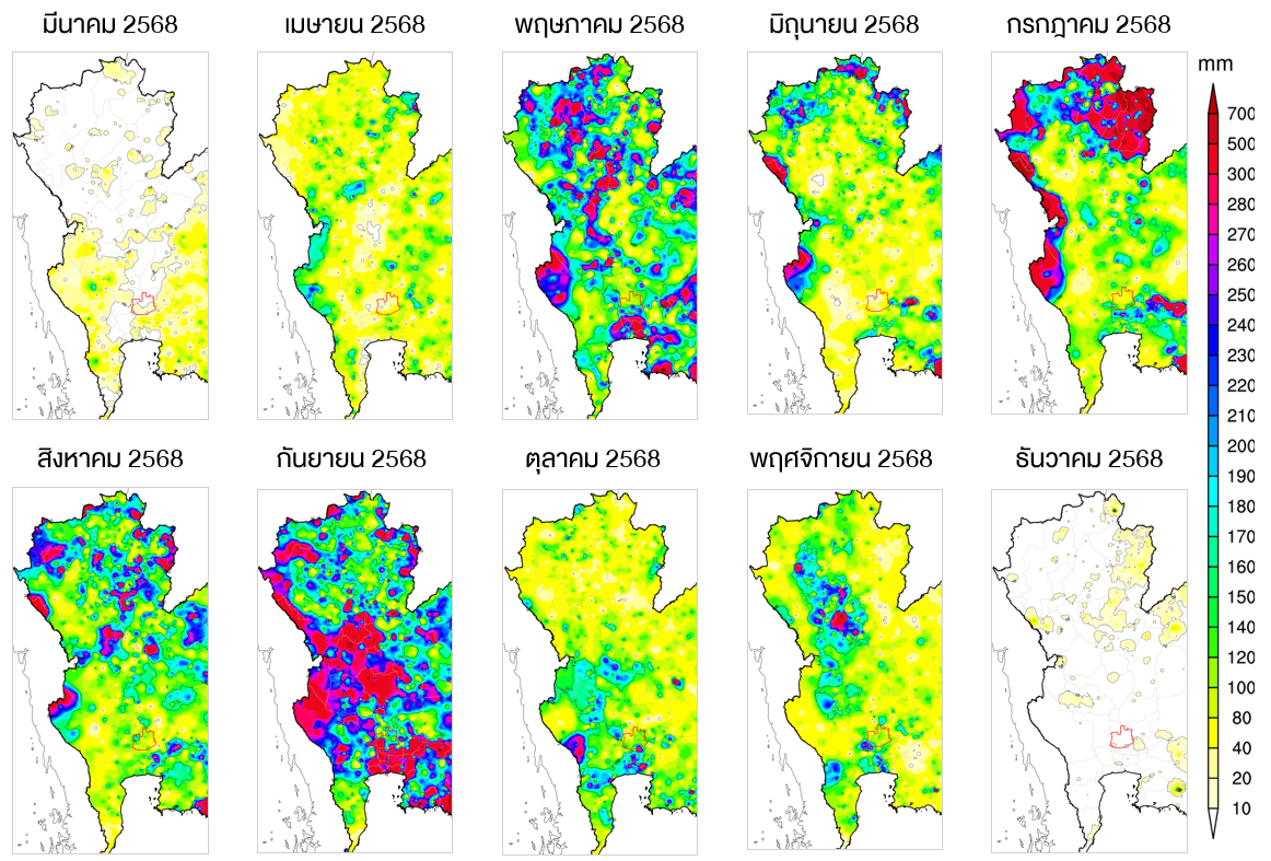
เดือนพฤษภาคมซึ่งเป็นเดือนแรกของการเข้าสู่ฤดูฝน บริเวณภาคเหนือและภาคกลางของประเทศไทยมีฝนตกหนักถึงหนักมากเกิดขึ้นเป็นหย่อม ๆ กระจายตัวในหลายพื้นที่และในเดือนนี้พื้นที่ลุ่มต่ำริมน้ำของจังหวัดพระนครศรีอยุธยาเริ่มเกิดน้ำล้นตลิ่งเข้าท่วม ต่างจากเดือนมิถุนายนที่ปริมาณฝนลดลงไปมาก แต่ก็กลับมามีฝนตกหนักมากอีกครั้งในพื้นที่ตอนบนของภาคเหนือในเดือนกรกฎาคม ซึ่งเดือนนี้ส่งผลทำให้เกิดน้ำท่วมในหลายพื้นที่ของภาคเหนือและภาคกลาง โดยเฉพาะในพื้นที่จังหวัดพระนครศรีอยุธยาที่สถานการณ์น้ำท่วมเริ่มมีความรุนแรงมากขึ้น ต่อมาในเดือนสิงหาคมบริเวณภาคเหนือยังคงมีฝนตกหนักถึงหนักมากเกิดขึ้นเป็นหย่อม ๆ ในหลายพื้นที่ และต่อเนื่องเข้าสู่เดือนกันยายนที่มีฝนตกหนักมากกระจายตัวเป็นบริเวณกว้างในพื้นที่ภาคเหนือตอนล่างและภาคกลาง ซึ่งทำให้เกิดน้ำล้นตลิ่งเข้าท่วมอย่างหนักเป็นบริเวณกว้างในพื้นที่ภาคกลางตลอดแนวทั้งแต่จังหวัดนครสวรรค์ไปจนถึงจังหวัดพระนครศรีอยุธยา โดยเฉพาะบริเวณจังหวัดพระนครศรีอยุธยาที่เกิดน้ำท่วมยาวนานต่อเนื่องมาหลายเดือน อีกทั้งในเดือนตุลาคมยังคงมีฝนตกหนักเข้ามาเติมปริมาณน้ำในพื้นที่ภาคกลางตอนล่าง ทำให้สถานการณ์ยังคงไม่คลี่คลาย และเมื่อเข้าสู่เดือนพฤศจิกายนที่โดยปกติแล้วแนวฝนจะเลื่อนลงสู่ภาคใต้ แต่ปีนี้กลับยังคงมีฝนตกหนักเกิดขึ้นในพื้นที่ภาคเหนือตอนล่าง จากอิทธิพลของพายุไต้ฝุ่น “คัลแมกี” ส่งผลให้ยังคงมีปริมาณน้ำเข้ามาเติมในพื้นที่ลุ่มน้ำเจ้าพระยาแม้ในความเป็นจริงจะสิ้นสุดฤดูฝนไปแล้ว
5. Rainfall
May, the first month of the rainy season, saw localized heavy to very heavy rainfall across the northern and central regions of Thailand, occurring in scattered areas. During this period, low-lying riverside areas in Phra Nakhon Si Ayutthaya Province began to experience river overflow and flooding.
In contrast, rainfall decreased significantly in June, but returned with very heavy intensity in the upper northern region in July. This led to flooding in many areas of the north and central regions, particularly in Phra Nakhon Si Ayutthaya Province, where the flood situation began to intensify.
In August, heavy to very heavy rainfall continued in parts of the northern region, followed by September, when widespread heavy rainfall affected the lower northern and central regions. This resulted in extensive river overflow and severe flooding along the central plains, from Nakhon Sawan Province down to Phra Nakhon Si Ayutthaya Province. In Ayutthaya, flooding persisted continuously for several months.
In October, continued heavy rainfall further added to water levels in the lower central region, preventing the situation from improving.
By November, although rainfall typically shifts southward, heavy rain still occurred in the lower northern region due to the influence of Typhoon “Kalmaegi”, continuing to add water to the Chao Phraya River Basin even though the rainy season had technically ended.
Map of Volume and Distribution of rainfall from March to December 2025
6.น้ำในเขื่อน
การกักเก็บน้ำไว้ในเขื่อนมีค่อนข้างมากประกอบกับมีฝนตกหนักสะสมในพื้นที่ตอนบนของลุ่มน้ำทำให้เขื่อนหลักจำเป็นต้องเร่งปล่อยน้ำ แต่กลับเป็นการเร่งระบายน้ำในจังหวะที่ไม่เหมาะสม เนื่องจากมีพื้นที่ท้ายน้ำที่กำลังประสบอุทกภัย ส่งผลให้มวลน้ำท่วมในพื้นที่มีเพิ่มขึ้นโดยเฉพาะที่จังหวัดพระนครศรีอยุธยาที่ได้รับความเดือดร้อนอย่างหนัก
6. Reservoir Storage
A large volume of water was stored in the reservoirs, combined with accumulated heavy rainfall in the upper basin. This situation forced the major dams to accelerate water releases. However, the timing of these releases was not appropriate, as downstream areas were already experiencing flooding.
As a result, the increased discharge further intensified flood conditions, particularly in Phra Nakhon Si Ayutthaya Province, which was severely affected.

หากเปรียบเทียบตัวเลขปริมาณน้ำของปี 2568 กับปี 2554 2560 และ 2565 ที่ประเทศไทยมีปริมาณฝนค่อนข้างมาก จะพบว่าปี 2568 เขื่อนภูมิพลและเขื่อนสิริกิติ์ มีปริมาณน้ำไหลลงเขื่อนสะสมทั้งปีและปริมาณน้ำระบายสะสมทั้งปี มากเป็นอันดับที่ 2 เป็นรองเพียงแค่ปี 2554 เท่านั้น อีกทั้งหากพิจารณาแยกข้อมูลเป็นรายเขื่อนจะพบว่าเขื่อนภูมิพลมีปริมาณน้ำไหลลงอ่างค่อนข้างมาก เกิดขึ้นเป็นระยะ ๆ ตั้งแต่ช่วงปลายเดือนพฤษภาคม 2568 แม้จะเข้าสู่ช่วงฤดูแล้งในเดือนพฤศจิกายนแล้ว แต่กลับยังคงมีน้ำไหลลงเขื่อนอยู่ค่อนข้างมาก หากเทียบกับปี 2554 2560 และ 2565 ที่ประเทศไทยมีปริมาณฝนค่อนข้างมาก
แต่ทั้งนี้ปริมาณน้ำไหลลงเขื่อนรายวันสูงสุดมีเพียง 135.89 ล้านลูกบาศก์เมตร ซึ่งเกิดขึ้นในวันที่ 25 กันยายน 2568 ซึ่งน้อยกว่าปี 2554 และ 2565 อยู่ค่อนข้างมาก แต่หากรวมปริมาณน้ำไหลลงเขื่อนสะสมตั้งแต่ต้นปีจนถึงปลายปี จะเห็นได้ว่า ปี 2568 มีปริมาณน้ำไหลลงเขื่อนสะสมถึง 10,313.04 ล้านลูกบาศก์เมตร ซึ่งเป็นรองแค่ปี 2554 เท่านั้น โดยได้เริ่มเร่งระบายน้ำออกตั้งแต่ช่วงต้นเดือนพฤศจิกายน 2568 และมีการระบายน้ำมากกว่า 50 ล้านลูกบาศก์เมตรต่อวัน ต่อเนื่องในช่วงวันที่ 12-17 พฤศจิกายน 2568
หลังจากนั้นได้ลดการระบายลงเหลือวันละ 30 ล้านลูกบาศก์เมตรต่อวัน ตั้งแต่วันที่ 25 พฤศจิกายน 2568 ไปจนถึงสิ้นปี รวมปริมาณน้ำระบายทั้งปี 7,239.71 ล้านลูกบาศก์เมตร ซึ่งมากเป็นอันดับสองรองจากปี 2554 เนื่องจากปริมาณน้ำไหลเข้าค่อนข้างมากหากไม่เร่งระบายอาจทำให้น้ำล้นเขื่อนได้ ซึ่งในช่วงกลางเดือนถึงปลายเดือนพฤศจิกายน 2568 ปริมาณน้ำมากเกือบถึงระดับกักเก็บปกติ (เกือบล้นเขื่อน) และเป็นปริมาณน้ำที่ใกล้เคียงกับปี 2554 ที่เกิดมหาอุทกภัยในประเทศไทย
When comparing water volume data for 2025 with other high-rainfall years such as 2011, 2017, and 2022, it is found that both Bhumibol Dam and Sirikit Dam recorded the second-highest annual cumulative inflow and discharge, ranking just behind 2011.
Looking specifically at Bhumibol Dam, inflow remained relatively high and occurred intermittently starting from late May 2025. Even during the dry season in November, inflow levels were still relatively high compared to the same period in 2011, 2017, and 2022, despite those being years with substantial rainfall.
However, the maximum daily inflow was 135.89 million cubic meters (mcm), recorded on 25 September 2025, which was still significantly lower than the peak daily inflows in 2011 and 2022.
When considering cumulative inflow over the entire year, 2025 recorded a total of 10,313.04 mcm, ranking second only to 2011. Due to the high inflow, water releases were accelerated starting in early November 2025, with discharge rates exceeding 50 mcm per day during 12–17 November 2025.
Afterward, discharge was reduced to approximately 30 mcm per day from 25 November through the end of the year. The total annual discharge reached 7,239.71 mcm, again ranking second only to 2011.
These increased releases were necessary to prevent reservoir overflow, as water levels during mid- to late November 2025 approached near-normal storage capacity (near full capacity). Overall, the water volume during this period was comparable to levels observed in 2011, the year of Thailand’s major flood disaster.


ส่วนเขื่อนสิริกิติ์ 2568 เขื่อนสิริกิติ์มีปริมาณน้ำไหลลงค่อนข้างมากเช่นเดียวกันกับเขื่อนภูมิพล โดยปริมาณน้ำไหลลงเขื่อนสะสมทั้งปีมีมากถึง 9,186.63 ล้านลูกบาศก์เมตร เป็นรองเพียงแค่ปี 2554 เท่านั้น แต่หากดูตัวเลขปริมาณน้ำไหลเข้ารายวันจะพบว่าระยะเวลาเพียง 1 วัน มีปริมาณน้ำไหลเข้ามากถึง 300.42 ล้านลูกบาศ์เมตร ซึ่งเกิดในวันที่ 26 กรกฎาคม 2568 และเป็นปริมาณน้ำที่มากกว่าปี 2554 ค่อนข้างมาก ทำให้ต้องเร่งระบายน้ำตลอดเดือนสิงหาคมและช่วงต้นเดือนถึงกลางเดือนตุลาคม 2568 แต่ปริมาณระบายยังคงน้อยกว่าปี 2554 ค่อนข้างมากหากเทียบกับช่วงเวลาเดียวกัน การระบายน้ำในช่วงเวลานี้เพื่อป้องกันไม่ให้เกิดเหตุการณ์น้ำล้นเขื่อน ซึ่งจะเห็นได้ว่าช่วงต้นเดือนตุลาคมถึงช่วงต้นเดือนธันวาคม 2568 ปริมาณน้ำจนเกือบถึงระดับกักเก็บปกติ
Regarding Sirikit Dam, in 2025 the reservoir received a significantly high volume of inflow, similar to Bhumibol Dam. The total annual inflow reached 9,186.63 mcm, second only to the level recorded in 2011. On a daily basis, the inflow peaked at 300.42 mcm in a single day on 26 July 2025, which was considerably higher than the corresponding figure in 2011. As a result, the dam had to accelerate water releases throughout August and from early to mid-October 2025. However, the discharge levels were still significantly lower than those in 2011 when compared over the same period. These releases were necessary to prevent the reservoir from exceeding its storage capacity. It is evident that from early October to early December 2025, the reservoir water level remained close to its normal storage capacity.


7. ปริมาณน้ำในลำน้ำ
ฝนที่ตกในพื้นที่ตอนบนของประเทศทั้งภาคเหนือและภาคกลางที่เกิดขึ้นตลอดช่วงฤดูฝนของปี 2568 ส่งผลทำให้ปริมาณน้ำในแม่น้ำสายหลักเพิ่มขึ้น และเกิดล้นตลิ่งเข้าท่วมในหลายพื้นที่ตลอดแนวริมน้ำ โดยเฉพาะบริเวณแม่น้ำน่านที่มีมวลน้ำค่อนข้างมากไหลลงพื้นที่ภาคกลางผ่านแม่น้ำเจ้าพระยา ประกอบกับมีฝนตกในพื้นที่ส่งผลทำให้แม่น้ำเจ้าพระยามีปริมาณน้ำค่อนข้างมากและเกิดน้ำท่วมเป็นระยะ ๆ ตั้งแต่ช่วงต้นฤดู
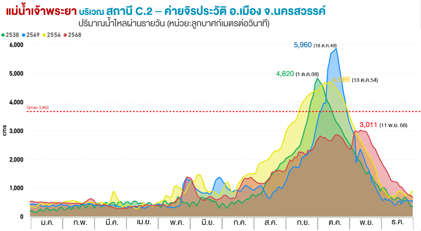
โดยที่ค่ายจิรประวัติ อ.เมืองนครสวรรค์ ถึงแม้ปริมาณน้ำไหลผ่าน ที่มองโดยภาพรวมแล้วดูเหมือนว่าจะน้อยกว่าปี 2538 2549 และ 2554 (ปีที่เกิดอุทกภัยรุนแรง) อยู่ค่อนข้างมาก แต่จะเห็นได้ว่ามีปริมาณน้ำไหลผ่านค่อนข้างมากกว่าปีที่เกิดอุทกภัยรุนแรง ได้เกิดขึ้นเป็นระยะ ๆ ตั้งแต่เดือนมิถุนายน 2568 โดยเฉพาะในช่วงเดือนพฤศจิกายนจนถึงสิ้นปีที่ปริมาณไหลผ่านมากกว่าอยู่ค่อนข้างมาก ทั้งนี้ปริมาณน้ำไหลผ่านสูงสุดอยู่ที่ 3,011 ลูกบาศก์เมตรต่อวินาที ซึ่งเกิดในวันที่ 11 พฤศจิกายน 2568 ซึ่งน้อยกว่าปริมาณน้ำไหลผ่านสูงสุดของปี 2538 2549 และ 2554 อยู่ค่อนข้างมาก
7. River Flow Conditions
Rainfall across the upper regions of Thailand—both the northern and central areas—throughout the 2025 rainy season led to increased water volumes in major rivers, causing frequent overflow and flooding along riverbanks. In particular, the Nan River carried a significant volume of water downstream into the central region via the Chao Phraya River. Combined with local rainfall, this resulted in consistently high-water levels in the Chao Phraya River and intermittent flooding from the early part of the season.
At Jiraprawat Camp (Mueang Nakhon Sawan District), although the overall flow appeared lower than during major flood years such as 1995, 2006, and 2011, there were periodic surges exceeding those years at certain times, beginning in June 2025. Notably, from November through the end of the year, flow volumes were significantly higher. The peak discharge reached 3,011 cubic meters per second on 11 November 2025, which was still considerably lower than the peak levels recorded in the major flood years.
ส่วนที่บริเวณคลองโผงเผง อ.บางบาล จ.พระนครศรีอยุธยา ปริมาณน้ำไหลถือว่าสูงมาก โดยเฉพาะตั้งแต่ช่วงเดือนกรกฎาคมไปจนถึงสิ้นปี และเกินศักยภาพของลำน้ำ (ล้นตลิ่ง) ตั้งแต่ช่วงเดือนสิงหาคมไปจนถึงสิ้นปี โดยเฉพาะช่วงเดือนพฤศจิกายนที่ปริมาณน้ำไหลผ่านมากกว่าปี 2549 และ 2554 โดยมีอัตราน้ำไหลผ่านสูงสุดอยู่ที่ 990 ลูกบาศก์เมตรต่อวินาที
At Khlong Phong Pheng (Bang Ban District, Phra Nakhon Si Ayutthaya), water flow was extremely high, particularly from July through the end of the year, exceeding channel capacity (bank overflow) from August onward. In November, flow levels were higher than those recorded in 2006 and 2011, with a peak discharge of 990 cubic meters per second.

สำหรับที่คลองบางบาล อ.บางบาล จ.พระนครศรีอยุธยา ปริมาณน้ำเกินความจุลำน้ำเกิดขึ้นเป็นระยะ ๆ ในช่วงเดือนตุลาคมถึงพฤศจิกายน 2568 โดยมีปริมาณน้ำไหลผ่านสูงสุด 185 ลูกบาศก์เมตรต่อวินาที ซึ่งเกิดขึ้นในวันที่ 13 พฤศจิกายน 2568
นอกจากนี้ยังตรวจพบสถานการณ์น้ำล้นตลิ่งบริเวณ
• คลองบางหลวง ต.บางหลวงโดด อ.บางบาล จ.พระนครศรีอยุธยา
• แม่น้ำเจ้าพระยา บริเวณสะพานธรรมจักร(วัดธรรมามูล) ต.ธรรมามูล อ.เมืองชัยนาท จ.ชัยนาท ต.ภูเขาทอง อ.พระนครศรีอยุธยา ต.ขนอนหลวง ต.บ้านกรด อ.บางปะอิน ต.โพแตง อ.บางไทร
ซึ่งส่วนใหญ่เป็นสถานการณ์น้ำล้นตลิ่งที่เกิดขึ้นต่อเนื่องยาวนานมากกว่า 2 เดือน
At Khlong Bang Ban (Bang Ban District, Phra Nakhon Si Ayutthaya), water levels exceeded channel capacity intermittently during October–November 2025, with a peak flow of 185 cubic meters per second on 13 November 2025.
Flooding due to river overflow was also observed at several locations, including:
• Khlong Bang Luang, Bang Luang Doet Subdistrict
• Chao Phraya River at Thammachak Bridge (Wat Thammamun), Thammamun Subdistrict (Mueang Chainat District), Phu Khao Thong Subdistrict (Phra Nakhon Si Ayutthaya District), Khanon Luang and Ban Krot Subdistricts (Bang Pa-in District), and Pho Taeng Subdistrict (Bang Sai District)
Most of these overflow events persisted continuously for more than two months.

8. สภาพพื้นที่ โครงสร้างน้ำและการบริหารจัดการ
8.1 จังหวัดพระนครศรีอยุธยาตั้งอยู่ในภูมิประเทศที่ราบลุ่มต่ำ และเป็นจุดรับน้ำจากแม่น้ำหลายสาย ประกอบด้วย แม่น้ำเจ้าพระยา แม่น้ำป่าสัก แม่น้ำน้อย และแม่น้ำลพบุรี ส่งผลทำให้เกิดน้ำเอ่อล้นตลิ่งเข้าท่วมชุมชนริมน้ำเป็นประจำเกือบทุกปี
8.2 การขยายตัวของบ่อทรายและโครงการก่อสร้างในทุ่งบางบาล ลดศักยภาพในการรับน้ำ และสร้างปัญหาสิ่งแวดล้อมซ้ำเติมเกษตรกร
8.3 ทางระบายน้ำเข้าไปสู่ทุ่งรับน้ำ เช่น ท่อลอด หรือประตูน้ำต่าง ๆ มีน้อย ทำให้ควบคุมน้ำได้ยาก
8.4 การบริหารจัดการน้ำควรมีส่วนร่วมจากชุมชนในพื้นที่มากยิ่งขึ้น
สถานการณ์น้ำท่วมปี 2568 นี้แสดงให้เห็นถึงความจำเป็นในการวางแผนจัดการน้ำที่มีประสิทธิภาพและเป็นธรรมมากยิ่งขึ้น เพื่อลดผลกระทบต่อชุมชนในพื้นที่รับน้ำท้ายเขื่อน
8. Physical Conditions, Water Infrastructure, and Management
8.1 Phra Nakhon Si Ayutthaya Province is located in a low-lying floodplain and serves as a receiving area for water from several major rivers, including the Chao Phraya River, Pa Sak River, Noi River, and Lopburi River. This geographical setting makes riverside communities highly prone to annual flooding due to frequent river overflow.
8.2 The expansion of sand mining operations and construction projects in the Bang Ban floodplain has reduced the area’s water retention capacity and created additional environmental challenges, further impacting local farmers.
8.3 There is a lack of sufficient infrastructure - such as culverts and water gates—for diverting water into flood retention fields, making water control and management more difficult.
8.4 Water management should involve greater participation from local communities to ensure more effective and inclusive decision-making.
The 2025 flood situation highlights the urgent need for more efficient and equitable water management planning, particularly to reduce the impact on downstream communities designated as flood retention areas.
(Satellite Imagery shows sand mining areas in Bang Ban Floodplain,Phra Nakhon Sri Ayutthaya Province