ปี 2568 เป็นอีกหนึ่งปีที่ประเทศไทยประสบกับปัญหาอุทกภัยรุนแรง ทั้งน้ำท่วมฉับพลันบริเวณอำเภอหาดใหญ่ จังหวัดสงขลา และน้ำท่วมขังเป็นระยะเวลายาวนานหลายเดือนที่จังหวัดพระนครศรีอยุธยา ซึ่งเกิดจากสภาวะอากาศที่แปรปรวน พายุที่เกิดผิดที่ผิดเวลา ส่งผลทำให้มีฝนตกมากในเวลาที่ไม่ควรตก จากที่ต้องเก็บน้ำไว้ใช้กลับต้องระบายน้ำเพิ่ม ความผันผวนของสถานการณ์น้ำที่เกิดขึ้นส่งผลทำให้มีความยากต่อการรับมือ
The year 2025 was another year in which Thailand experienced severe flooding, ranging from flash floods in Hat Yai District, Songkhla Province, to prolonged inundation lasting several months in Phra Nakhon Si Ayutthaya Province. These events were driven by highly variable weather conditions and tropical storms occurring at unusual times and locations, resulting in excessive rainfall during periods when rainfall would normally be limited. Instead of storing water for future use, water managers were forced to increase reservoir releases to cope with the excess inflow. Such fluctuations in hydrological conditions significantly increased the complexity of flood management and disaster response efforts.
ฝนที่ตกมากก็มากเกิน ฝนที่ตกน้อยก็น้อยเกิน
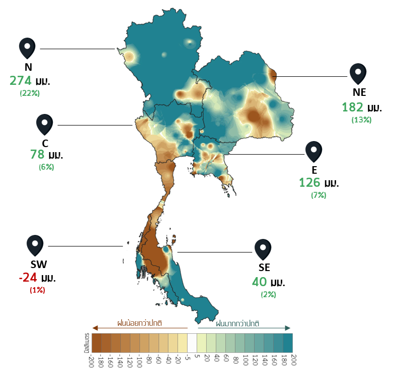
ปี 2568 ประเทศไทยมีฝนตกเฉลี่ยทั้งประเทศประมาณ 1,670 มิลลิเมตร มากกว่าปกติประมาณ 11% โดยมีฝนตกมากกว่าปกติเกิดขึ้นเกือบทุกพื้นที่ในภาคเหนือ รวมถึงตอนบนและด้านตะวันตกของภาคตะวันออกเฉียงเหนือ ตอนบนของภาคกลางและตอนล่างของภาคใต้ ถึงแม้ในภาพรวมทั้งประเทศจะมีปริมาณฝนมากกว่าปกติ แต่กลับยังคงมีฝนตกน้อยกว่าปกติเกิดขึ้นในหลายพื้นที่ โดยเฉพาะทางด้านตะวันตกของประเทศตั้งแต่จังหวัดกาญจนบุรี รวมถึงจังหวัดทางด้านตะวันตกของภาคกลาง ครอบคลุมพื้นที่ตลอดแนวยาวลงไปตอนล่างของประเทศจนถึงบริเวณจังหวัดนครศรีธรรมราชที่มีฝนตกน้อยกว่าปกติเกิดขึ้นเกือบทุกพื้นที่ อีกทั้งภาคตะวันออกเฉียงเหนือที่มีฝนตกน้อยกว่าปกติเกิดขึ้นในหลายพื้นที่เช่นกัน ส่วนภาคตะวันออกมีฝนตกน้อยกว่าปกติเกิดขึ้นเป็นหย่อมเล็ก ๆ ในหลายพื้นที่
When it rains, it rains too much; when it doesn't, there's too little rain
In 2025, Thailand recorded an average annual rainfall of approximately 1,670 mm nationwide, which was about 11% above the climatological normal. Above-normal rainfall occurred across most areas of Northern Thailand, as well as the upper and western parts of the Northeastern region, the upper part of the Central region, and the lower part of Southern Region. Although rainfall of the whole country was above-normal, below-normal rainfall was still observed in several areas. In particular, western side areas of the country, starting from Kanchanaburi Province and extending through the western provinces of the Central region, experienced below-normal rainfall along a continuous corridor stretching southward to Nakhon Si Thammarat Province, where rainfall was below normal in almost all areas. In addition, several parts of the Northeastern region also received below-normal rainfall. In the Eastern region, below-normal rainfall occurred in scattered localized areas.
เหตุการณ์ฝนตกหนักที่เกิดขึ้นในฤดูแล้ง
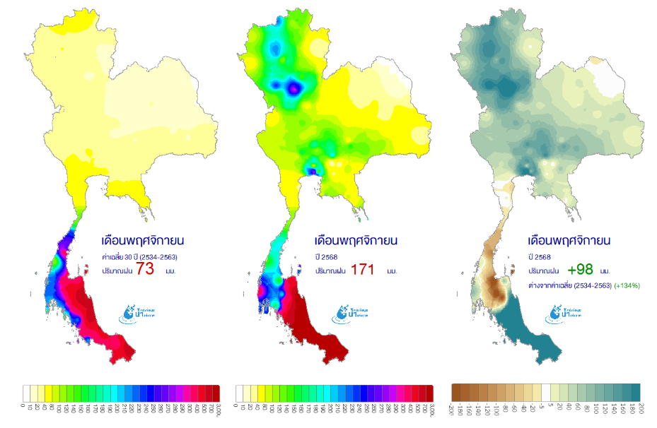
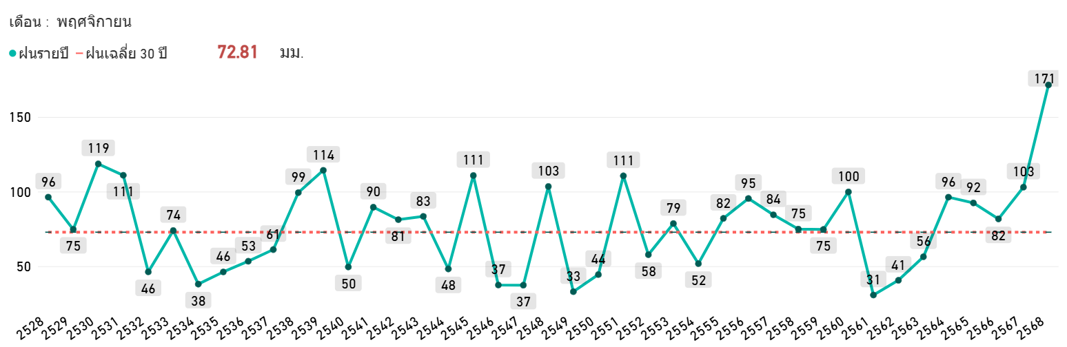
เมื่อวิเคราะห์ข้อมูลฝนแยกเป็นรายเดือนจะเห็นได้ว่ามีอยู่ 5 เดือน ที่ฝนตกน้อยกว่าปกติ ได้แก่ มกราคม มีนาคม สิงหาคม ตุลาคม และธันวาคม ส่วน 7 เดือนที่เหลือนั้นมีฝนตกมากกว่าปกติ โดยเฉพาะเดือนพฤศจิกายนที่มีฝนตกมากอย่างผิดปกติที่สุดถึง 98% เนื่องจากเป็นเดือนที่บริเวณตอนบนของประเทศได้เข้าสู่ฤดูแล้งแล้ว แต่ยังคงมีฝนตกหนักมากกว่าปกติในหลายพื้นที่ทางตอนบนของประเทศ ทั้งภาคเหนือ ภาคตะวันออกเฉียงเหนือ ภาคกลาง ภาคตะวันออก อีกทั้งพื้นที่ภาคใต้ตอนล่างก็มีฝนตกหนักมากด้วยเช่นกัน
Unseasonably heavy rainfall during the dry season
A monthly analysis of rainfall revealed that there were five months with below-normal rainfall: January, March, August, October, and December. The remaining seven months experienced above-normal rainfall. November was particularly exceptional, recording rainfall approximately 98% above the climatological normal, making it the wettest anomaly of the year. This was mainly because, although the upper part of Thailand had already entered the dry season, many areas continued to receive significantly heavier rainfall than normal. Above-normal rainfall was observed across the Northern, Northeastern, Central, and Eastern regions, while the lower Southern region also experienced exceptionally heavy rainfall.
“คัลแมกี” พายุที่มาผิดที่...ผิดเวลา
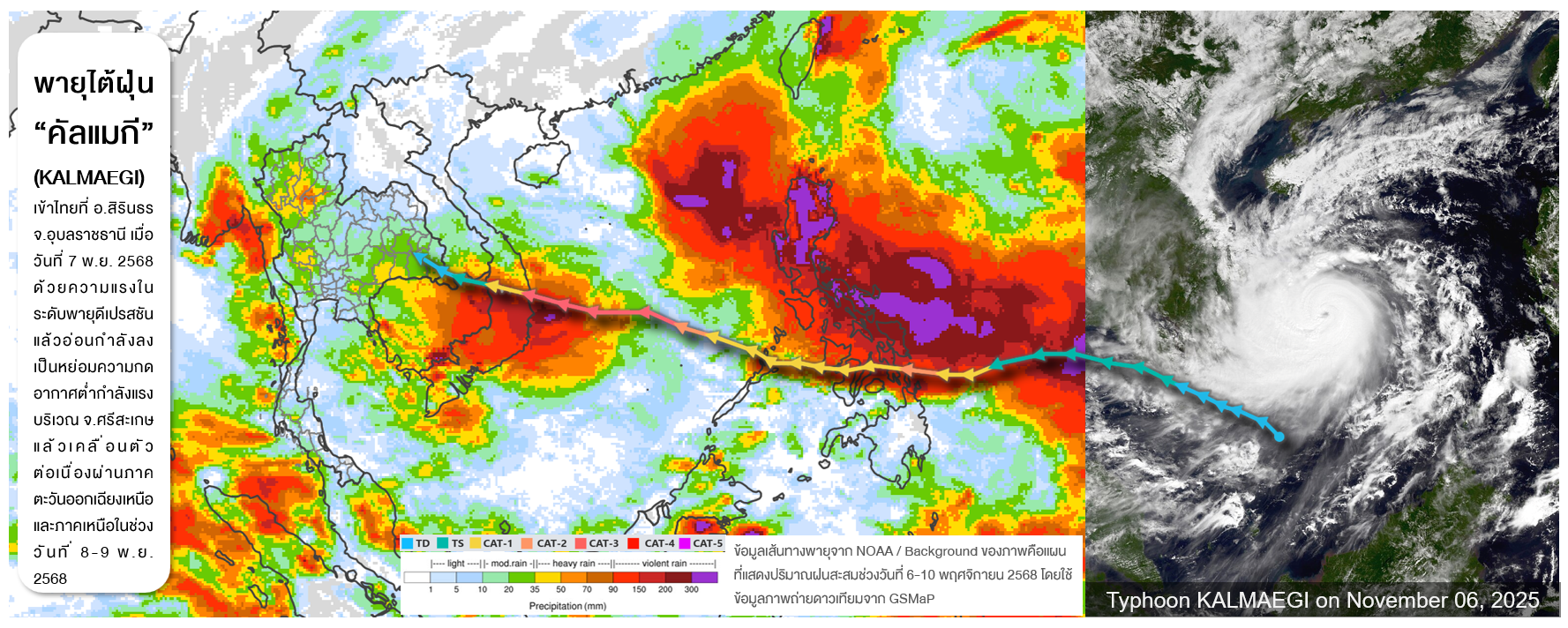
พายุคือหนึ่งในปัจจัยที่ทำให้เกิดฝนตกหนักในปี 2568 พายุไต้ฝุ่น “คัลแมกี” (KALMAEGI) คือพายุลูกเดียวที่เคลื่อนเข้าสู่ประเทศไทยในปีนี้ โดยเข้าไทยบริเวณอำเภอสิรินธร จังหวัดอุบลราชธานี ในวันที่ 7 พฤศจิกายน 2568 ในขณะลดระดับลงเป็นพายุดีเปรสชันแล้ว ซึ่งต่อมาได้อ่อนกำลังลงต่อเนื่องเป็นหย่อมความกดอากาศต่ำกำลังแรงบริเวณจังหวัดศรีสะเกษ แล้วเคลื่อนตัวต่อเนื่องไปยังภาคเหนือ ก่อนเคลื่อนเข้าประเทศเมียนมา อิทธิพลของพายุส่งผลทำให้ภาคตะวันออกเฉียงเหนือและภาคเหนือมีฝนเพิ่มขึ้นในช่วงวันที่ 6-10 พฤศจิกายน 2568 ซึ่งถือเป็นเหตุการณ์ที่เกิดขึ้นไม่บ่อยนัก เนื่องจากเดือนพฤศจิกายนเป็นช่วงฤดูแล้งในพื้นที่ตอนบนของประเทศ ดังที่กล่าวไปแล้วข้างต้น ซึ่งพายุมักจะเลื่อนตัวลงไปเข้าไทยที่บริเวณภาคใต้มากกว่าพื้นที่ตอนบนของประเทศ
“KALMAEGI”: A Storm Out of Place and Out of Season
Tropical storms were one of the contributing factors to the heavy rainfall observed in Thailand during 2025. Typhoon KALMAEGI was the only storm that arrived in Thailand during the year. The system entered the country at Sirindhorn District, Ubon Ratchathani Province, on 7 November 2025, after it had weakened to a tropical depression. It subsequently continued to weaken into an active low-pressure area over Sisaket Province before moving northward across Northern Thailand and eventually into Myanmar. The influence of KALMAEGI resulted in increased rainfall over the Northeastern and Northern regions during 6–10 November 2025. This was a relatively uncommon event, as November normally marks the beginning of the dry season in the upper part of Thailand. As discussed previously, tropical storms during this period typically track farther south and affect the Southern region rather than the upper part of the country.
ช่วงเวลาแห่งการเก็บน้ำ....แต่กลับต้องเร่งระบายน้ำ
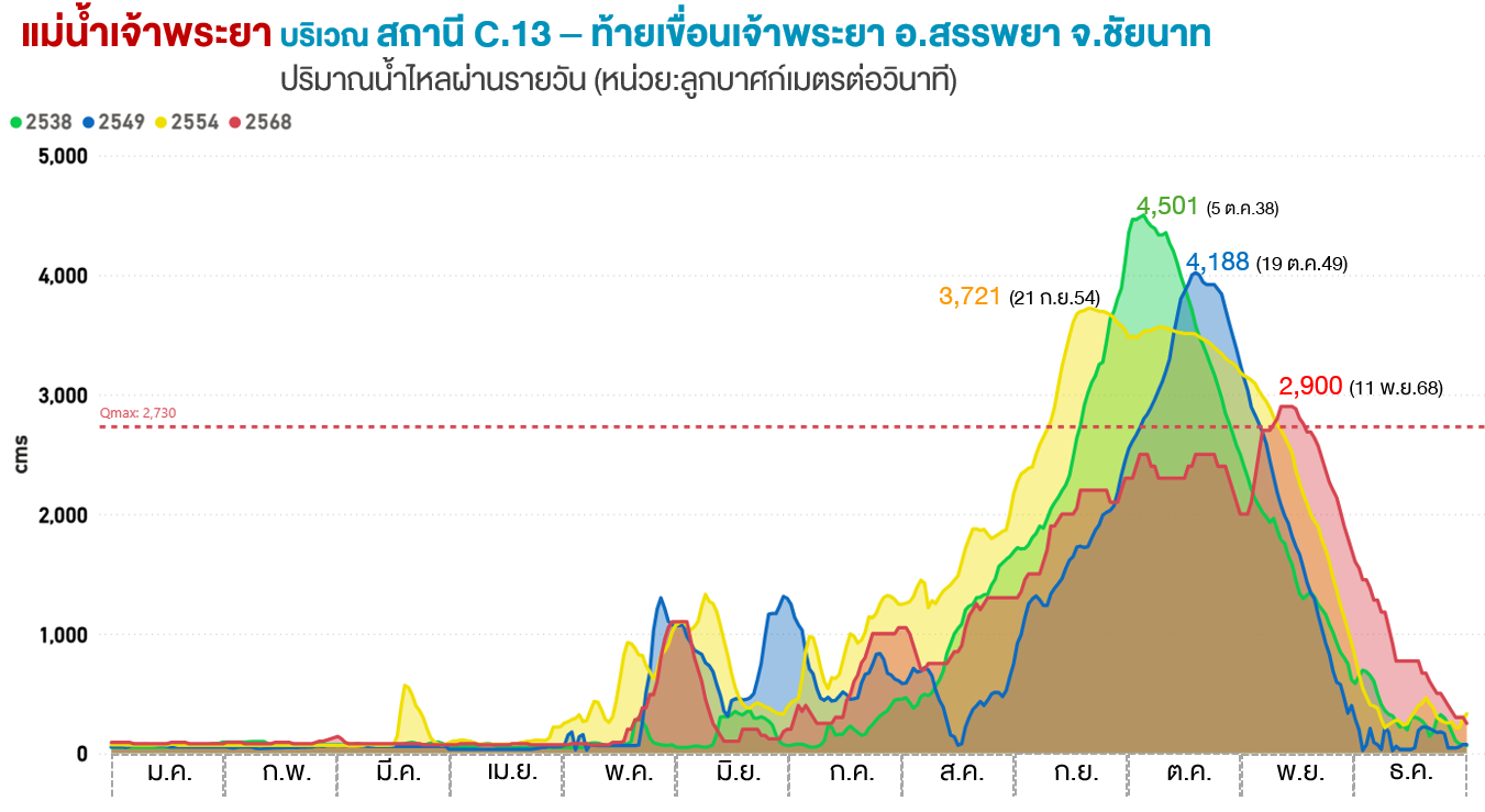
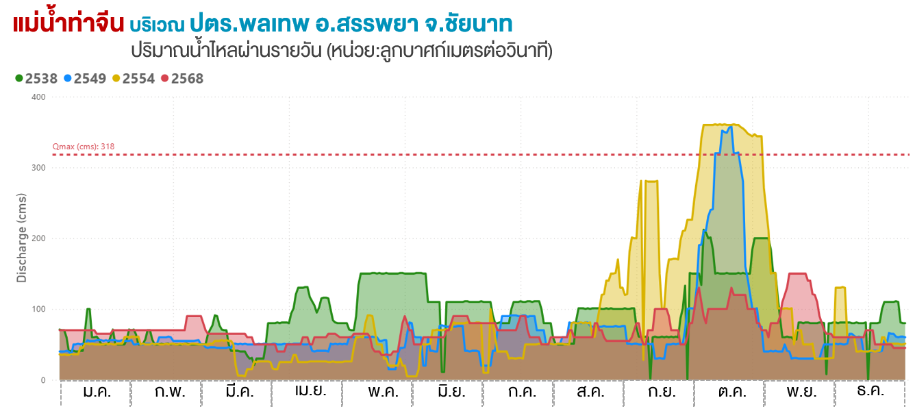
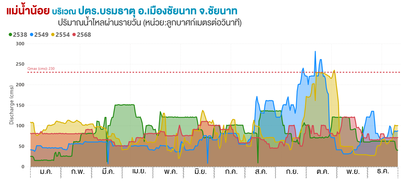
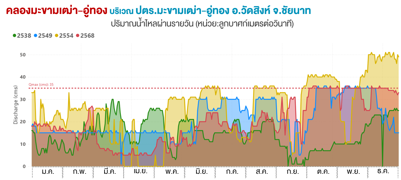
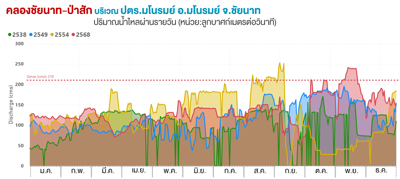
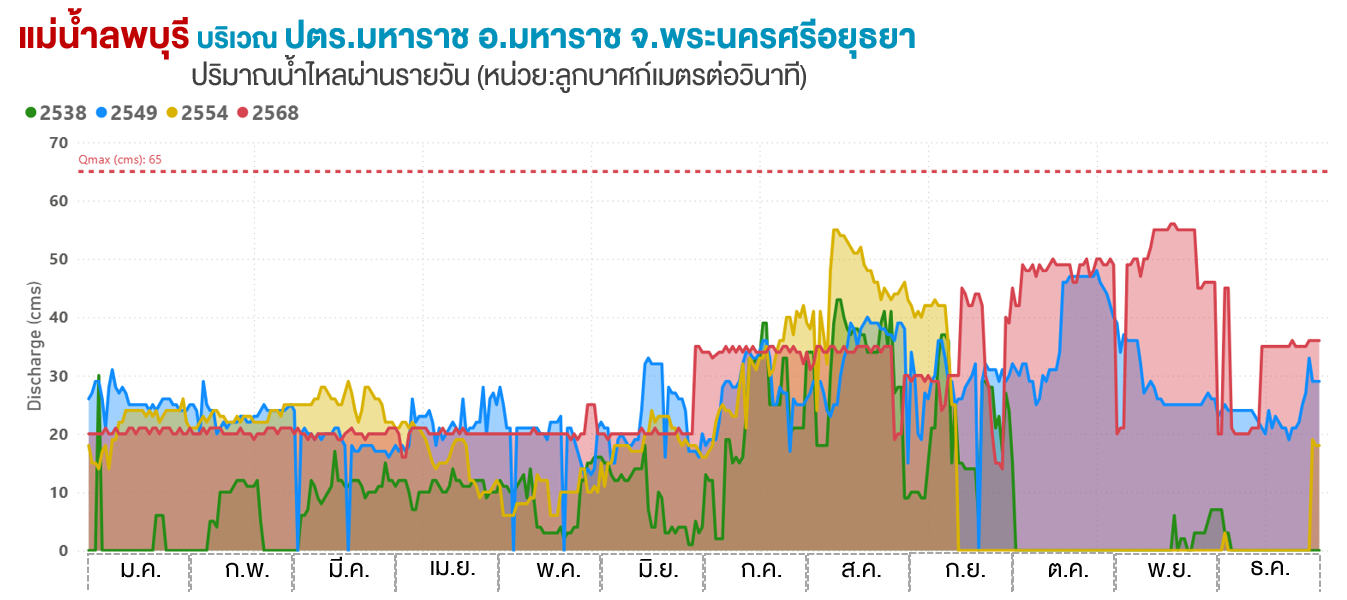
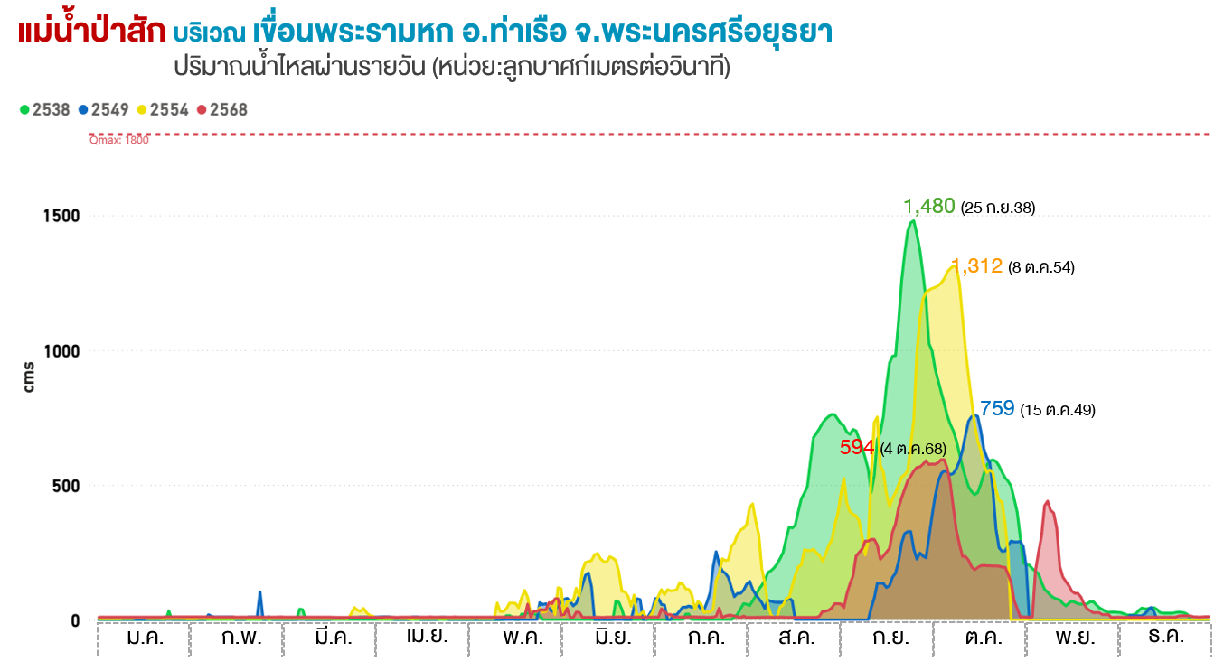
อีกทั้งเดือนพฤศจิกายนเป็นช่วงที่ต้องเริ่มกักเก็บน้ำ เขื่อนต่าง ๆ ต้องเริ่มกักเก็บน้ำเพื่อเอาไว้ใช้ในช่วงฤดูแล้ง แต่ในปีนี้ประตูระบายน้ำสำคัญต่าง ๆ ยังคงต้องระบายน้ำจำนวนมากในช่วงเวลาดังกล่าวเพื่อเป็นการลดระดับน้ำที่มีมากจนเกินไป ทั้งที่เขื่อนเจ้าพระยา ประตูระบายน้ำมโนรมย์ ประตูระบายน้ำพลเทพ ประตูระบายน้ำบรมธาตุ ประตูระบายน้ำมะขามเฒ่า-อู่ทอง ประตูระบายน้ำมหาราช ที่ใช้ควบคุมปริมาณน้ำในแม่น้ำเจ้าพระยา รวมถึงเขื่อนพระรามหกที่ใช้ควบคุมปริมาณน้ำที่แม่น้ำป่าสัก เหตุการณ์นี้คือหนึ่งในตัวแปรสำคัญที่ทำให้ยังคงมีน้ำท่วมพื้นที่ภาคกลางโดยเฉพาะจังหวัดพระนครศรีอยุธยาเกิดขึ้นยาวนานต่อเนื่องไปจนถึงช่วงต้นปี 2569
A time for storing water... yet we are forced to urgently drain it away
Moreover, November is generally a period when water resources are being conserved, and reservoirs begin storing water for the upcoming dry season. However, during this event, several major water-control structures were required to maintain high discharge rates to reduce higher water level. These included the Chao Phraya Dam, Manorom Regulator Gate, Pholthep Regulator Gate, Borommathat Regulator Gate, Makham Tao–U Thong Regulator Gate, Maharaj Regulator Gate, which regulate flows within the Chao Phraya River system,
as well as the Rama VI Dam, which regulates flows in the Pasak River. This event was one of the key factors contributing to the prolonged flooding in the Central Plain, particularly in Phra Nakhon Si Ayutthaya Province, where flood conditions persisted continuously into early 2026.
พายุที่ไม่ได้เข้าไทย....แต่สร้างภัยร้ายแรง
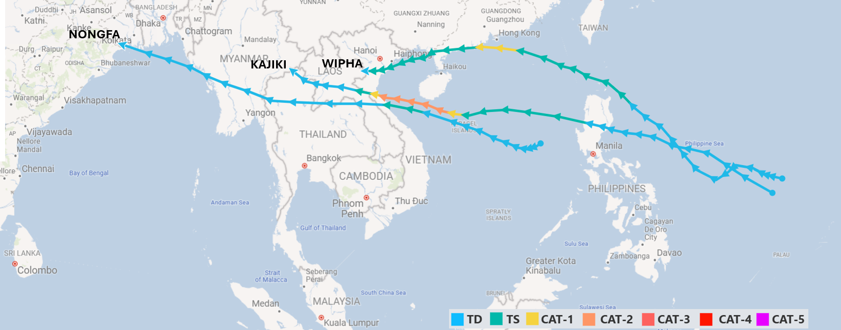
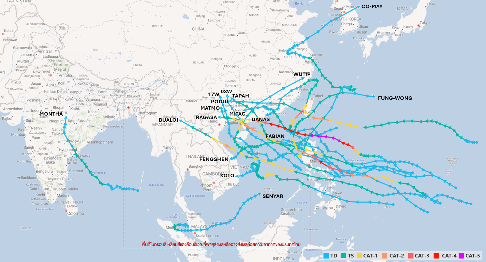
นอกจากพายุไต้ฝุ่น “คัลแมกี” แล้วยังมีพายุอีก 3 ลูก ที่เคลื่อนเข้าสู่ประเทศไทยในขณะที่สลายตัวลงเป็นหย่อมความกดอากาศต่ำแล้ว ซึ่งทั้งหมดส่งผลกระทบต่อภาคเหนือและภาคตะวันออกเฉียงเหนือของไทย ประกอบด้วย
1) พายุไต้ฝุ่น “วิภา” (WIHPA) ที่ส่งผลกระทบในช่วงปลายเดือนกรกฎาคม 2568 พายุลูกนี้ทำให้จังหวัดน่านเกิดน้ำท่วมรุนแรง
2) พายุไต้ฝุ่น “คาจิกิ” (KAJIKI) ส่งผลกระทบในช่วงปลายเดือนสิงหาคม 2568 และ
3) พายุโซนร้อน “หนองฟ้า” (NONGFA) ส่งผลกระทบในช่วงปลายเดือนสิงหาคมถึงต้นเดือนกันยายน 2568
นอกจากนี้ยังมีพายุอีก 17 ลูกที่ถึงแม้จะไม่ได้เคลื่อนเข้าสู่ประเทศไทยโดยตรง แต่ได้เคลื่อนเข้ามาสลายตัวบริเวณประเทศเพื่อนบ้านหรือเคลื่อนตัวเข้ามายังบริเวณที่ส่งผลกระทบต่อสภาพอากาศของประเทศไทย โดยฉพาะพายุไซโคลน “ซินยาร์” (SENYAR) ที่ส่งผลทำให้เกิดฝนตกหนักและเกิดน้ำท่วมบริเวณภาคใต้ตอนล่าง โดยเฉพาะที่อำเภอหาดใหญ่ จังหวัดสงขลา
A Storm That Never Hit Thailand... Yet Caused Severe Damage
In addition to Typhoon KALMAEGI, three other storms influenced Thailand after weakening into low-pressure systems before entering the country. Although these systems had dissipated from storm status, they still contributed to enhanced rainfall over Northern and Northeastern Thailand.
These systems included:
1) Typhoon WIHPA, which affected Thailand in late July 2025. The remnants of this storm contributed to severe flooding in Nan Province.
2) Typhoon KAJIKI, which affected the country during late August 2025.
3) Tropical Storm NONGFA, which affected Thailand from late August to early September 2025.
In addition, 17 other tropical storms affected Thailand indirectly during 2025. Although these systems did not arrive in Thailand, they either dissipated over neighboring countries or moved into positions where their circulation patterns influenced Thailand's weather conditions. Among these systems, Cyclone SENYAR was particularly significant. Its influence contributed to widespread heavy rainfall and flooding in the lower Southern region of Thailand. Severe flooding was reported in several areas, especially in Hat Yai District, Songkhla Province.
เข้าสู่เดือนพฤศจิกายน...แทนที่น้ำจะลดแต่กลับเพิ่มขึ้น
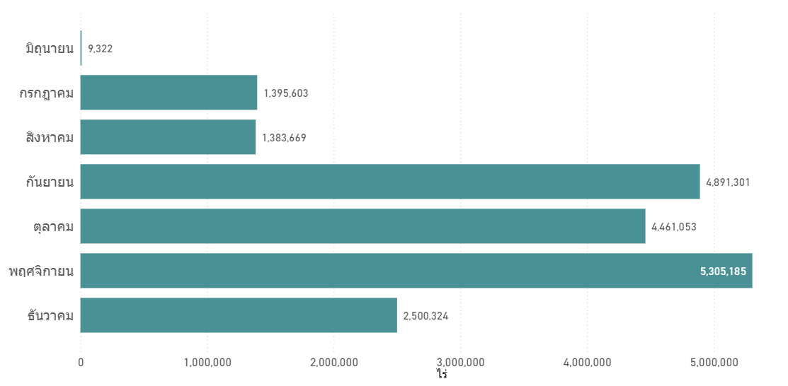
จากการวิเคราะห์พื้นที่น้ำท่วมโดยใช้ข้อมูลจากภาพถ่ายดาวเทียม พบว่าในปี 2568 ประเทศไทยมีพื้นที่ถูกน้ำท่วมประมาณ 9.49 ล้านไร่ กระจายตัวอยู่ในทุกภาคของประเทศ โดยมี 59 จังหวัด 509 อำเภอ 3,133 ตำบล ที่เกิดน้ำท่วมในพื้นที่ ทั้งนี้ดาวเทียมได้ตรวจพบพื้นที่น้ำท่วมจำนวน 7 เดือน เริ่มตั้งแต่เดือนกรกฎาคมจนถึงเดือนธันวาคม โดยเดือนพฤศจิกายนมีพื้นที่ถูกน้ำท่วมมากที่สุดประมาณ 5.31 ล้านไร่ รองลงมาคือเดือนกันยายน 4.90 ล้านไร่ และเดือนตุลาคม 4.46 ล้านไร่ ซึ่งถือเห็นเหตุการณ์ที่ค่อนข้างผิดปกติจากที่เคยเป็น เนื่องจากโดยปกติแล้วพื้นที่น้ำท่วมมักเกิดขึ้นอนข้างมากในช่วงเดือนสิงหาคมถึงตุลาคม และจะลดลงในช่วงเดือนพฤศจิกายนเป็นต้นไปเนื่องจากได้เริ่มเข้าสู่ฤดูแล้ง แต่ในปีนี้เดือนพฤศจิกายนกลับยังคงมีพื้นที่น้ำท่วมเพิ่มขึ้นจากเดือนตุลาคม ซึ่งมีสาเหตุมาจากได้รับผลกระทบจากพายุคัลแมกี ดังที่กล่าวไปแล้วข้างต้น
Entering November, water levels are rising rather than falling
Analysis of satellite-derived flood inundation data indicated that approximately 9.49 million rai of land across Thailand was affected by flooding in 2025. Flooded areas were distributed throughout all regions of the country, affecting 59 provinces, 509 districts, and 3,133 subdistricts. Satellite observations detected flood inundation over a seven-month period, from July through December. The largest flooded area was recorded in November, covering approximately 5.31 million rai, followed by September with 4.90 million rai and October with 4.46 million rai. This pattern was considered unusual compared with the typical seasonal flood cycle in Thailand. Under normal conditions, flood extent generally reaches its peak during August–October and gradually decreases from November onward as the country transitions into the dry season. However, in 2025, the flooded area continued to expand in November and exceeded the extent observed in October. The primary reason for this anomaly was the influence of Typhoon KALMAEGI, as discussed earlier.
น้ำไหลลงเขื่อนมากที่สุดในรอบ 10 ปี
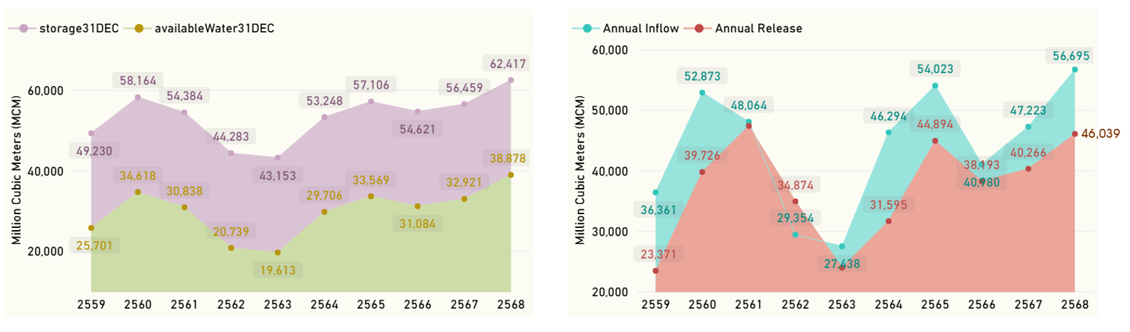
ปี 2568 เขื่อนขนาดใหญ่ทั้ง 35 แห่งทั่วประเทศ มีปริมาณน้ำไหลลงเขื่อนสะสมรวมกันทั้งปี 56,695 ล้านลูกบาศก์เมตร มากที่สุดเมื่อเทียบกับข้อมูลย้อนหลังในรอบ 10 ปี แต่ก็มีการระบายน้ำออกไปมากถึง 46,039 ล้านลูกบาศก์เมตร ซึ่งมากเป็นอันดับที่ 2 รองจากปี 2561 ทำให้ ณ วันสิ้นปี มีน้ำกักเก็บคงเหลือ 62,417 ล้านลูกบาศก์เมตร (88% ของความจุเขื่อน) อยู่ในเกณฑ์น้ำมาก ซึ่งมากที่สุดหากเทียบกับข้อมูลย้อนหลังในรอบ 10 ปี เป็นปริมาณน้ำใช้การได้จริง 38,878 ล้านลูกบาศก์เมตร และแม้จะมีการระบายน้ำออกไปเป็นจำนวนมากแล้วก็ตาม แต่ ณ วันสิ้นปี ยังมีเขื่อน 2 แห่ง ที่ยังคงเกิดสถานการณ์น้ำล้นเขื่อน คือ เขื่อนแม่งัด จ.เชียงใหม่ และเขื่อนกิ่วคอหมา จ.ลำปาง ส่วนเขื่อนที่มีปริมาณน้ำเก็บกักคงเหลืออยู่ในเกณฑ์น้ำมากมี 12 แห่ง น้ำปานกลาง 15 แห่ง น้ำน้อย 5 แห่ง และมีเพียงเขื่อนลำตะคองเพียงเขื่อนเดียวที่มีปริมาณน้ำกักเก็บคงเหลืออยู่ในเกณฑ์น้ำน้อยวิกฤต
Highest Dam Inflow in 10 Years
In 2025, the combined annual inflow to Thailand’s 35 major reservoirs reached 56,695 million cubic meters, the highest volume recorded over the past decade. Reservoir releases were also exceptionally high, totaling 46,039 million cubic meters, ranking second only to 2018. As of 31 December 2025, total reservoir storage stood at 62,417 million cubic meters, equivalent to 88% of total reservoir capacity. This level was classified as a high storage condition and represented the highest year-end storage volume recorded during the past ten years. Of this amount, 38,878 million cubic meters were classified as usable storage. Despite the substantial releases throughout the year, two reservoirs remained in an overflow condition at year-end: Mae Ngat Reservoir in Chiang Mai Province and Kiu Lom Reservoir in Lampang Province. Based on reservoir storage classifications at the end of the year, 12 reservoirs were in the high-storage category, 15 reservoirs were in the normal-storage category, and 5 reservoirs were in the low-storage category. Only Lam Takhong Reservoir remained in the critically low-storage category.
เขื่อนภูมิพลมีปริมาณน้ำไหลเข้ามาก เป็นรองเพียงแค่ปี 2554 เท่านั้น
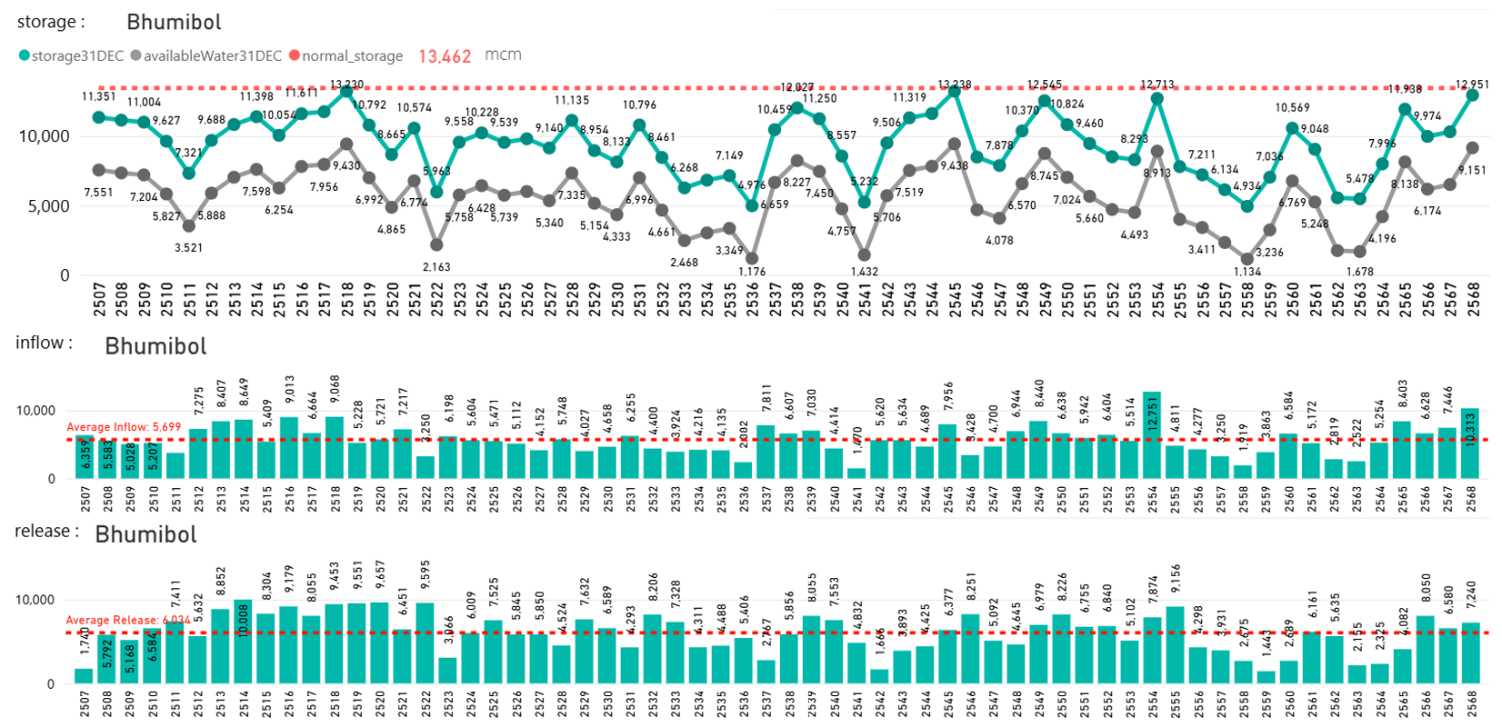
สำหรับเขื่อนภูมิพล ในปี 2568 มีปริมาณน้ำไหลลงเขื่อนสะสมทั้งปีมากถึง 10,313 ล้านลูกบาศก์เมตร มากเป็นอันดับที่ 2 รองจากปี 2554 หากเทียบกับข้อมูลตั้งแต่มีการสร้างเขื่อน ทำให้ช่วงปลายปี ปริมาณน้ำกักเก็บของเขื่อนจึงมีมากถึง 12,951 ล้านลูกบาศก์เมตร หรือ 96% ของความจุเขื่อน อยู่ในเกณฑ์น้ำมาก โดยมากเป็นอันดับที่ 3 รองจากปี 2545 และปี 2518 หากเทียบกับข้อมูลตั้งแต่มีการสร้างเขื่อน
Bhumibol Dam’s annual inflow has been exceptionally high, surpassed only by the year 2011
For Bhumibol Reservoir, the cumulative annual inflow in 2025 reached 10,313 million cubic meters, ranking as the second-highest annual inflow since the reservoir was commissioned, surpassed only by the record inflow observed in 2011. As a result of the exceptionally high inflow, reservoir storage increased substantially during the latter part of the year. By the end of 2025, storage volume had reached 12,951 million cubic meters, equivalent to 96% of the reservoir’s total capacity, placing the reservoir in the high-storage category. This year-end storage volume ranked as the third-highest on record since the reservoir began operation, exceeded only by the storage levels recorded in 2002 and 1975.
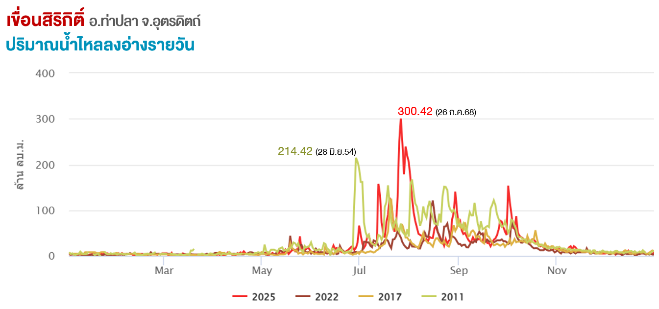
เขื่อนสิริกิติ์ทุบสถิติน้ำไหลลงเขื่อนรายวันมากกว่าปี 2554
ส่วนเขื่อนสิริกิติ์ ในปี 2568 มีปริมาณน้ำไหลลงเขื่อนสะสมทั้งปี 9,187 ล้านลูกบาศก์เมตร มากที่สุดเป็นอันดับที่ 2 เป็นรองเพียงแค่ปี 2554 เท่านั้น หากเทียบกับข้อมูลตั้งแต่มีการสร้างเขื่อน แต่หากดูตัวเลขปริมาณน้ำไหลเข้ารายวันจะพบว่าระยะเวลาเพียง 1 วัน มีปริมาณน้ำไหลเข้ามากถึง 300.42 ล้านลูกบาศ์เมตร ซึ่งเกิดในวันที่ 26 กรกฎาคม 2568 และเป็นปริมาณน้ำที่มากกว่าปี 2554 ค่อนข้างมาก ทำให้ต้องเร่งระบายน้ำตลอดเดือนสิงหาคมและช่วงต้นเดือนถึงกลางเดือนตุลาคม 2568
แต่ปริมาณระบายยังคงน้อยกว่าปี 2554 ค่อนข้างมาก หากเทียบกับช่วงเวลาเดียวกัน การระบายน้ำในช่วงเวลานี้เพื่อป้องกันไม่ให้เกิดเหตุการณ์น้ำล้นเขื่อน ซึ่งจะเห็นได้ว่าช่วงต้นเดือนตุลาคมถึงช่วงต้นเดือนธันวาคม 2568 ปริมาณน้ำมีมากจนเกือบถึงระดับกักเก็บปกติ และเป็นระดับที่ใกล้เคียงกับปี 2554 ทั้งนี้จากการะบายน้ำออกดังกล่าว ทำให้เขื่อนสิริกิติ์มีปริมาณน้ำกักเก็บคงเหลือ ณ วันสิ้นปีอยู่ที่ 8,837 ล้านลูกบาศก์เมตร (93% ของความจุเขื่อน) อยู่ในเกณฑ์น้ำมาก โดยเป็นปริมาณน้ำใช้การได้จริง 5,987 ล้านลูกบาศก์เมตร
Sirikit Dam Sets New Daily Inflow Record, Exceeding 2011 Levels
For Sirikit Reservoir, the cumulative annual inflow in 2025 reached 9,187 million cubic meters, ranking as the second-highest annual inflow since the reservoir was commissioned, surpassed only by the exceptionally wet year of 2011. Analysis of daily inflow data revealed that the reservoir received as much as 300.42 million cubic meters of inflow on a single day, occurring on 26 July 2025. This daily inflow exceeded the corresponding peak inflow recorded during 2011 by a considerable margin. Consequently, reservoir operators were required to increase water releases throughout August and again during early to mid-October 2025 to manage the rapidly rising storage levels. Despite these releases, the discharge volumes remained substantially lower than those recorded during the same period in 2011. The increased releases were implemented as a flood mitigation measure to prevent the reservoir from reaching overflow conditions. As a result of the exceptionally high inflows, reservoir storage remained near the normal conservation level from early October to early December 2025, approaching levels comparable to those observed during 2011. Following these reservoir operations, storage at Sirikit Reservoir stood at 8,837 million cubic meters at the end of 2025, equivalent to 93% of total reservoir capacity. This placed the reservoir in the high-storage category, with 5,987 million cubic meters classified as usable storage.
สถานการณ์น้ำปี 2568 สะท้อนให้เห็นถึงความแปรปรวนของสภาพอากาศที่รุนแรงมากขึ้น ทั้งลักษณะฝนที่เปลี่ยนไป พายุที่เกิดผิดฤดูกาล รวมถึงปริมาณน้ำไหลเข้าเขื่อนในระดับสูงเป็นประวัติการณ์ ถึงแม้ปีนี้ประเทศไทยจะมีน้ำต้นทุนจำนวนมากสำหรับรองรับช่วงฤดูแล้ง แต่เหตุการณ์น้ำท่วมที่เกิดขึ้นยืดเยื้อยาวนาน รวมถึงน้ำท่วมฉับพลันที่สร้างความเสียหายอย่างมหาศาล ที่เกิดขึ้นในปีนี้ ก็เป็นสัญญาณสำคัญที่ต้องเร่งปรับตัวและบริหารจัดการทรัพยากรน้ำให้มีประสิทธิภาพมากยิ่งขึ้นในอนาคต
The water situation in 2025 highlighted the increasing severity of climate variability, reflected in changing rainfall patterns, out-of-season tropical storms, and record-high inflows into major reservoirs. Although Thailand entered the dry season with abundant water resources, the prolonged flooding and devastating flash flood events experienced throughout the year underscored the growing challenges of water management. These events serve as an important warning that Thailand must accelerate its efforts to adapt and enhance the efficiency of water resource management in order to strengthen resilience against future climate and hydrological extremes.