summary:Flooding caused by the influence of Typhoon “KAJIKI” and Tropical Storm “NONGFA” from late August to early September 2025

ช่วงเวลาที่เกิดพายุ "คาจิกิ" และพายุ "หนองฟ้า"
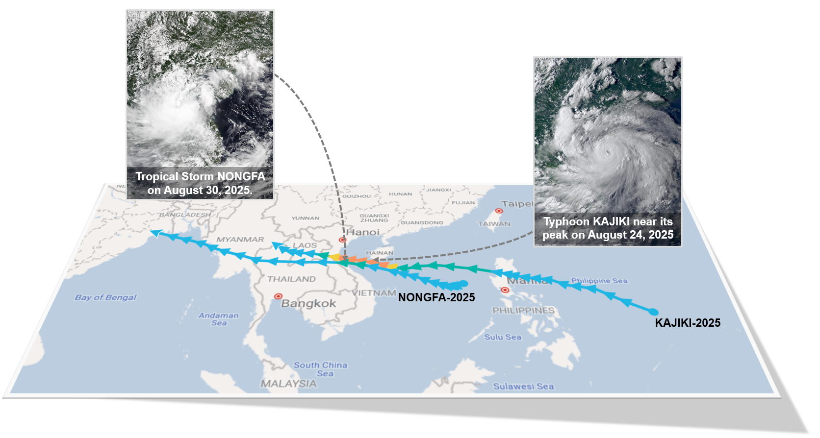
พายุไต้ฝุ่น “คาจิกิ” (KAJIKI) เริ่มก่อตัวเป็นหย่อมความกดอากาศต่ำที่บริเวณมหาสมุทรแปซิฟิกด้านตะวันออกของประเทศฟิลิปปินส์ตั้งแต่วันที่ 19 สิงหาคม 2568 หลังจากนั้นได้เคลื่อนตัวต่อเนื่องไปทางทิศตะวันตกเฉียงเหนือแล้วทวีกำลังแรงขึ้นเป็นพายุดีเปรสชันและพายุโซนร้อนในวันที่ 22 สิงหาคม 2568 ก่อนเคลื่อนตัวผ่านเกาะลูซอนลงทะเลจีนใต้ในวันเดียวกัน ต่อมาได้เพิ่มกำลังแรงขึ้นเป็นพายุไต้ฝุ่น ระดับที่ 1 และ 2 ในวันที่ 24 สิงหาคม 2568 ขณะเคลื่อนตัวอยู่เหนือทะเลนอกชายฝั่งทางตอนใต้ของเกาะไหหลำ แล้วลดกำลังลงเป็นพายุไต้ฝุ่นระดับ 1 อีกครั้งในวันที่ 25 สิงหาคม 2568 พร้อมเคลื่อนขึ้นฝั่งบริเวณตอนล่างของเมืองวิญ ประเทศเวียดนาม ในวันเดียวกัน จากนั้นได้อ่อนกำลังลงเป็นพายุโซนร้อนแล้วเคลื่อนตัวปกคุลมบริเวณแขวงบอลิคำไซ ไซยสมบูรณ์ ประเทศลาว ในวันที่ 26 สิงหาคม 2568 แล้วอ่อนกำลังลงต่อเนื่องเป็นพายุดีเปรสชันขณะเคลื่อนตัวอยู่บริเวณแขวงไชยะบุรี ประเทศลาว ก่อนสลายตัวเป็นหย่อมความกดอากาศต่ำกำลังแรงเคลื่อนเข้าปกคลุมบริเวณจังหวัดน่านในวันเดียวกัน หลังจากนั้นได้เคลื่อนเข้าปกคลุมตอนบนของประเทศเมียนมา ในวันที่ 27 สิงหาคม 2568
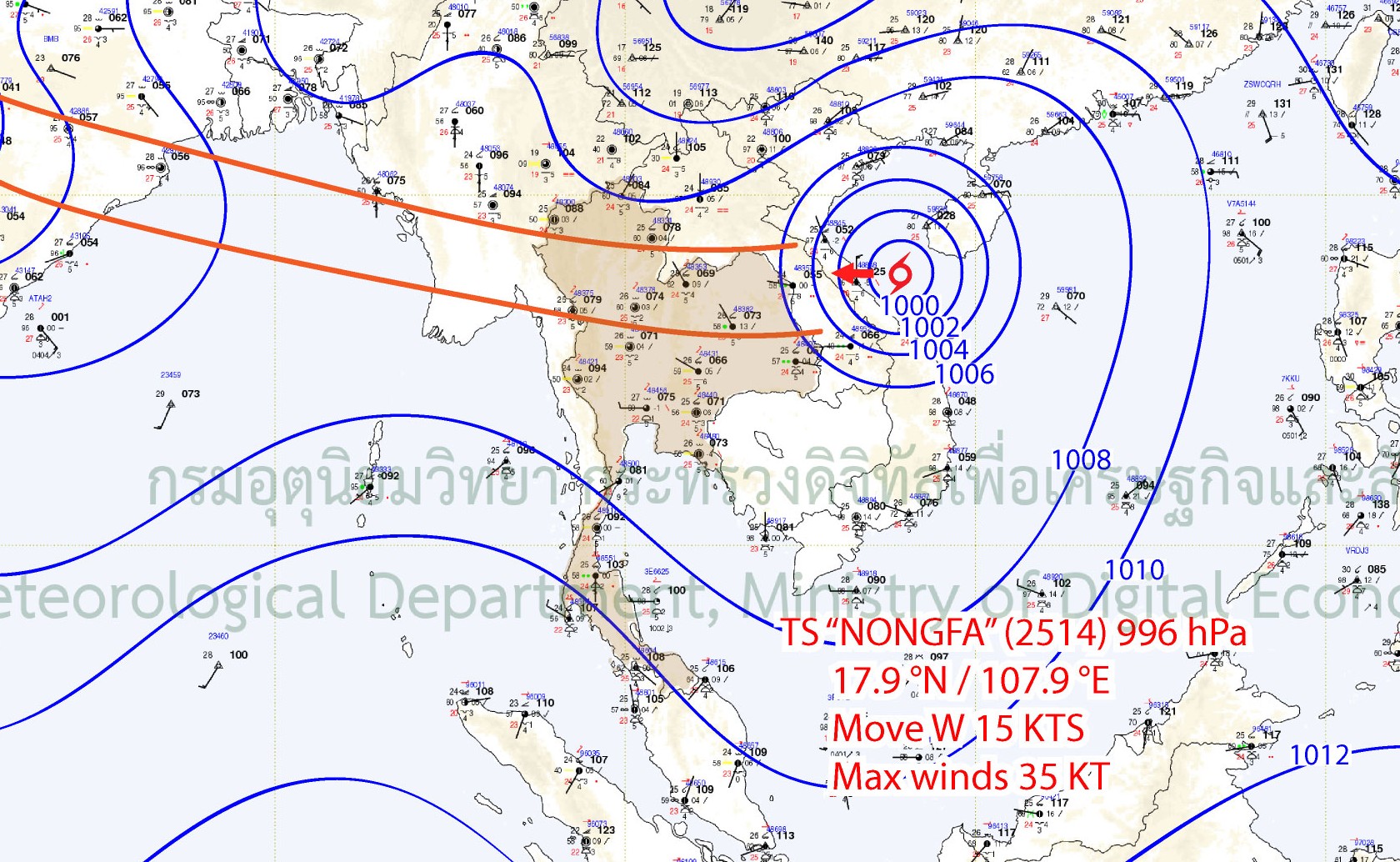
หลังจากพายุไต้ฝุ่น “คาจิกิ” ได้สลายตัวไป ได้มีพายุก่อตัวขึ้นใหม่อีก 1 ลูก ชื่อว่า “หนองฟ้า” (NONGFA) ที่ก่อตัวขึ้นเป็นหย่อมความกดอากาศต่ำบริเวณตอนกลางของทะเลจีนใต้ เมื่อวันที่ 27 สิงหาคม 2568 หลังจากนั้นได้ทวีกำลังแรงขึ้นเป็นพายุดีเปรสชันในวันที่ 28 สิงหาคม 2568 แล้วทวีกำลังแรงขึ้นต่อเนื่องเป็นพายุโซนร้อนในวันที่ 30 สิงหาคม 2568 ขณะเคลื่อนตัวอยู่นอกชายฝั่งทางตอนใต้ของเกาะไหหลำ ซึ่งต่อมาได้เคลื่อนผ่านตอนกลางของประเทศเวียดนามเข้าสู่ประเทศลาวพร้อมอ่อนกำลังลงเป็นพายุดีเปรสชันในช่วงเย็นของวันเดียวกัน จากนั้นได้อ่อนกำลังลงเป็นหย่อมความกดอากาศต่ำเคลื่อนเข้าปกคลุมบริเวณภาคตะวันออกเฉียงเหนือตอนบนและภาคเหนือตอนล่างของไทยในวันที่ 31 สิงหาคม 2568
Timeline of "KAJIKI" and "NONGFA"
On 19 August 2025, Typhoon “KAJIKI” started to form as a low-pressure cell over the Pacific Ocean on the east side of the Philippines. After that, it persistently moved northwestward and strengthened into a tropical depression and subsequently a tropical storm on 22 August 2025, before moving across the Luzon Island to the South China Sea on the same day. Later, it intensified into a Category 1 and subsequently Category 2 typhoon on 24 August 2025, while moving over the sea near the southern coast of Hainan Island. It then weakened back to a Category 1 typhoon again on 25 August 2025 and made landfall over the lower part of Vinh City, Vietnam on the same day. After landfall, it downgraded into a tropical storm and moved across Bolikhamsai and Xaisomboun Provinces, Laos on 26 August 2025 and continuously weakened into a tropical depression while it moved over Xayaburi Province, Laos before decayed to a strong low-pressure cell and moved to cover Nan Province on the same day. After that, it moved to cover the northern Myanmar on 27 August 2025
After the dissipation of typhoon KAJIKI, the one new storm named “NONGFA” formed as a low-pressure cell over the central area of the South China Sea on 27 August 2025. It later intensified into a tropical depression on 28 August 2025 and continuously upgraded into a tropical storm on 30 August while moving over the sea near the southern coast of Hainan Island. Later, it moved across the central Vietnam into Laos, then weakened into a tropical depression in the evening of the same day. Further, it dissipated into a low-pressure area covering the upper northeastern and lower northern regions of Thailand on 31 August 2025.
หย่อมควากดอากาศต่ำ ร่องมรสุมและมรสุมตะวันตกเฉียงใต้
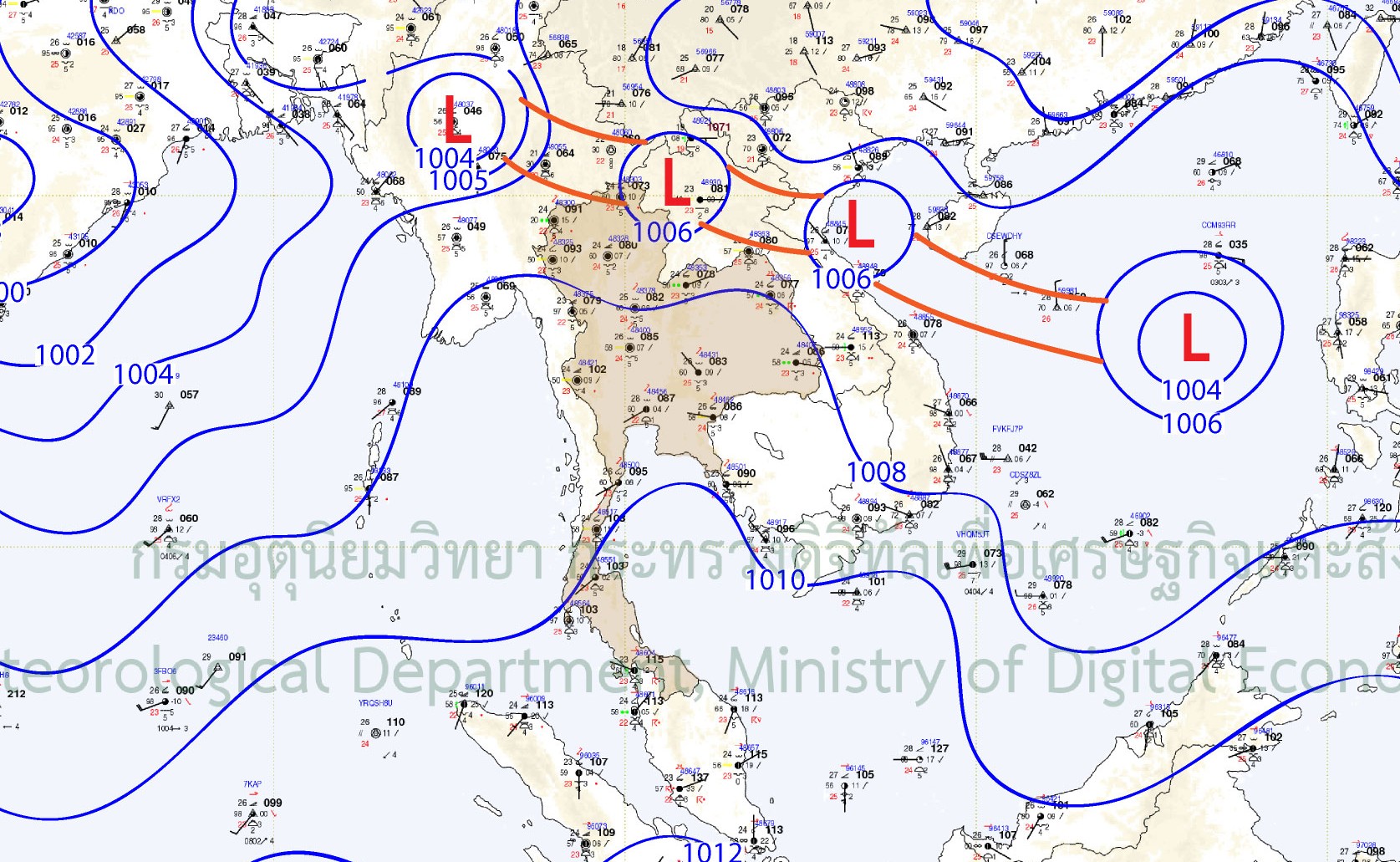
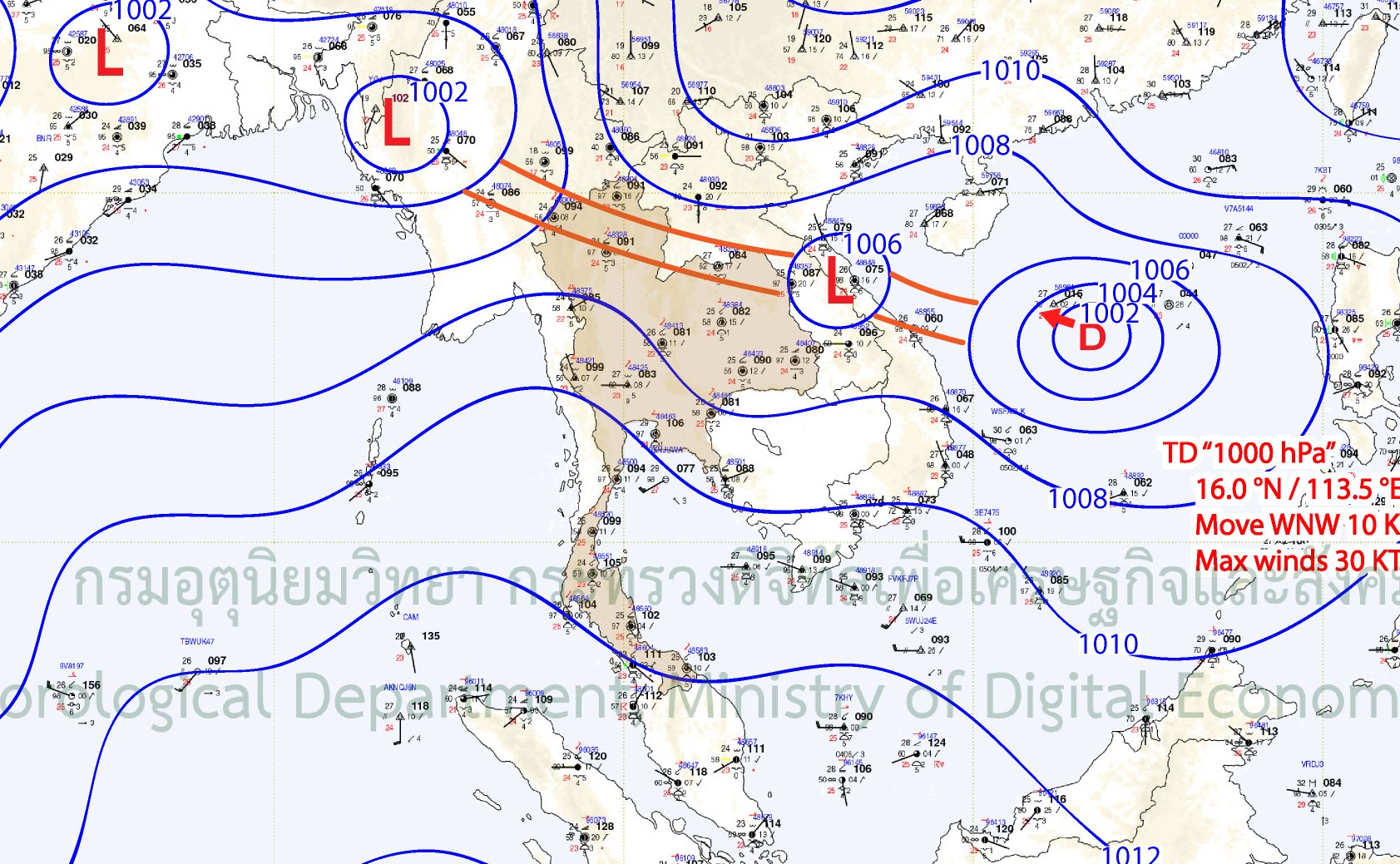
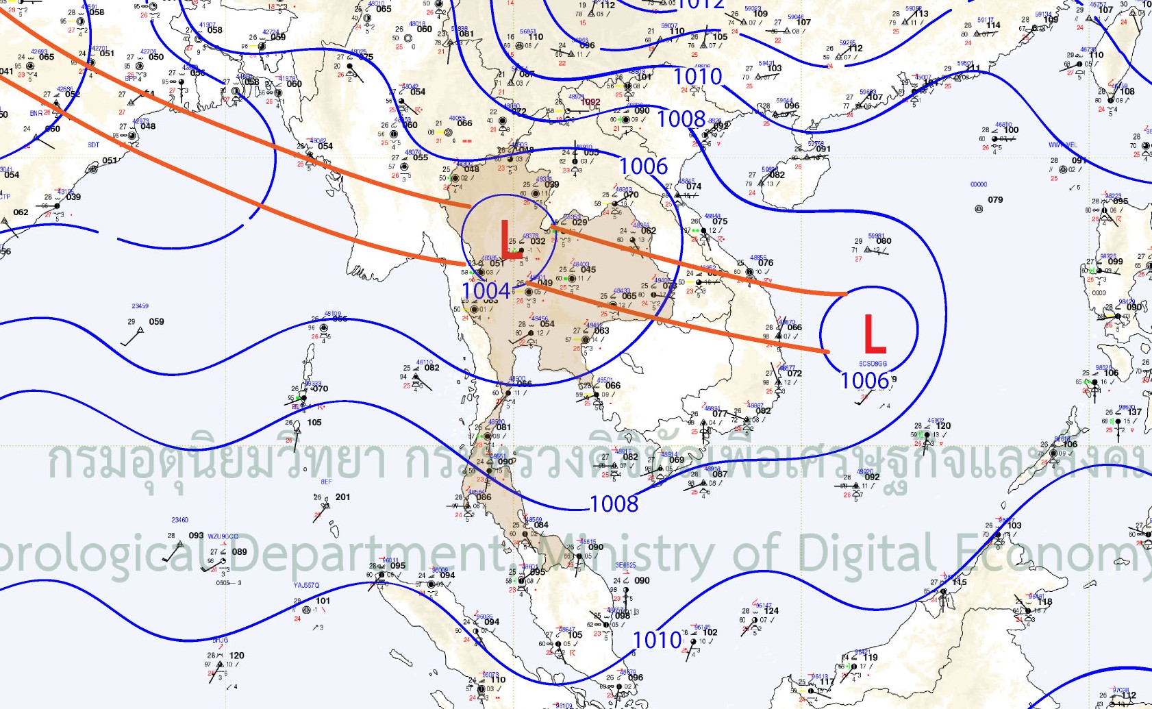
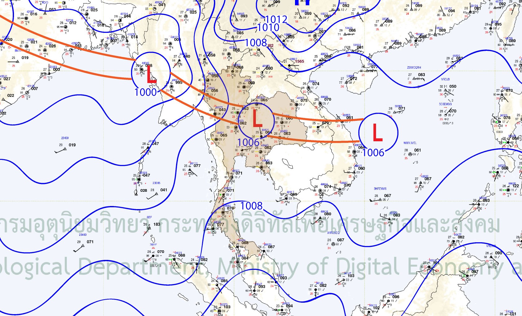
วันที่ 23 สิงหาคม 2568 มีร่องมรสุมพาดผ่านบริเวณภาคเหนือและภาคตะวันออกเฉียงเหนือของไทยทำให้มีฝนตกในบริเวณดังกล่าวรวมถึงพื้นที่ใกล้เคียง ประกอบกับในช่วงเวลาเดียวกันพายุโซนร้อน “คาจิกิ” ได้เคลื่อนผ่านประเทศฟิลิปปินส์เข้ามายังทะเลจีนใต้ และเคลื่อนเข้าสู่อ่าวตังเกี๋ยในช่วงวันที่ 24-25 สิงหาคม 2568 แล้วเพิ่มกำลังแรงขึ้นเป็นพายุไต้ฝุ่น และได้มีร่องมรสุมเกิดมรสุมพาดผ่านบริเวณภาคเหนือและภาคตะวันออกเฉียงเหนือเข้าสู่พายุดังกล่าว ต่อมาในวันที่ 26 สิงหาคม 2568 พายุคาจิกิได้เคลื่อนเข้าสู่ประเทศเวียดนามแล้วสลายตัวเป็นหย่อมความกดอากาศต่ำและทำให้เกิดร่องมรสุมพาดผ่านภาคเหนือและภาคตะวันออกเฉียงเหนืออีกครั้งในช่วงวันที่ 27 สิงหาคม 2568 ซึ่งในเวลาเดียวกันได้เกิดหย่อมความกดอากาศต่ำบริเวณทะเลจีนใต้ใกล้ชายฝั่งประเทศฟิลิปปินส์ ซึ่งในวันต่อมาได้มีร่องมรสุมพาดผ่านภาคเหนือเข้าสู่หย่อมความกดอากาศต่ำดังกล่าว ก่อนที่จะเพิ่มกำลังแรงเป็นพายุดีเปรสชัน “หนองฟ้า” ในวันที่ 29 สิงหาคม 2568 และยังคงมีร่องมรสุมพาดผ่านบริเวณภาคเหนือและภาคตะวันออกเฉียงเหนือเข้าสู่พายุ “หนองฟ้า” ที่ได้เพิ่มกำลังแรงขึ้นเป็นพายุโซนร้อนในวันที่ 30 สิงหาคม 2568 ก่อนที่จะสลายตัวเป็นหย่อมความกดอากาศต่ำในวันที่ 31 สิงหาคม 2568 แต่ยังคงมีร่องมรสุมพาดผ่านภาคเหนือและภาคตะวันออกเฉียงเหนืออย่างต่อเนื่องออกไปอีกอย่างต่อเนื่องตลอดเดือนกันยายน 2568 นอกจากนี้อิทธิพลของพายุทั้งสองลูกยังส่งผลทำให้มรสุมตะวันตกเฉียงใต้มีกำลังแรงขึ้น ซึ่งทำให้บริเวณด้านตะวันตกของภาคใต้และภาคตะวันออกมีฝนตกเพิ่มมากขึ้น
The Low-pressure area, Monsoon trough, and Southwest monsoon
On 23 August, the monsoon trough lay across the North and the Northeast of Thailand. It caused rain in those areas and nearby areas. At the same time, Tropical Storm “KAJIKI” moved across the Philippines into the South China Sea, then moving to enter the Gulf of Tonkin during 24-25 August 2025. Subsequently, it strengthened into a typhoon, accompanied by the monsoon trough lay across the North and the Northeast into that typhoon.
Later, on 26 August 2025, Typhoon KAJIKI moved into Vietnam and dissipated into low-pressure area that resulted in the reformation of monsoon trough lay across the North and the Northeast of Thailand on 27 August 2025. At the same time, the low-pressure area occurred in the South China Sea near the coast of the Philippines. On the following day, the monsoon trough extended across the North of Thailand toward this low-pressure area, which later intensified into Tropical Depression “NONGFA” on 29 August 2025.
The monsoon trough continuously lay across the North and the Northeast toward “NONGFA” which had strengthened into Tropical Storm on 30 August 2025 that later decayed into low-pressure area on 31 August 2025. Nevertheless, the monsoon trough persistently lay across the North and the Northeast throughout September 2025. Furthermore, the influence of both storms also strengthened the southwest monsoon that resulted in the west side of the South, and the East experienced more rainfall.
The weather map of monsoon troughs continuously across Thailand during 27 August and 1 September 2025
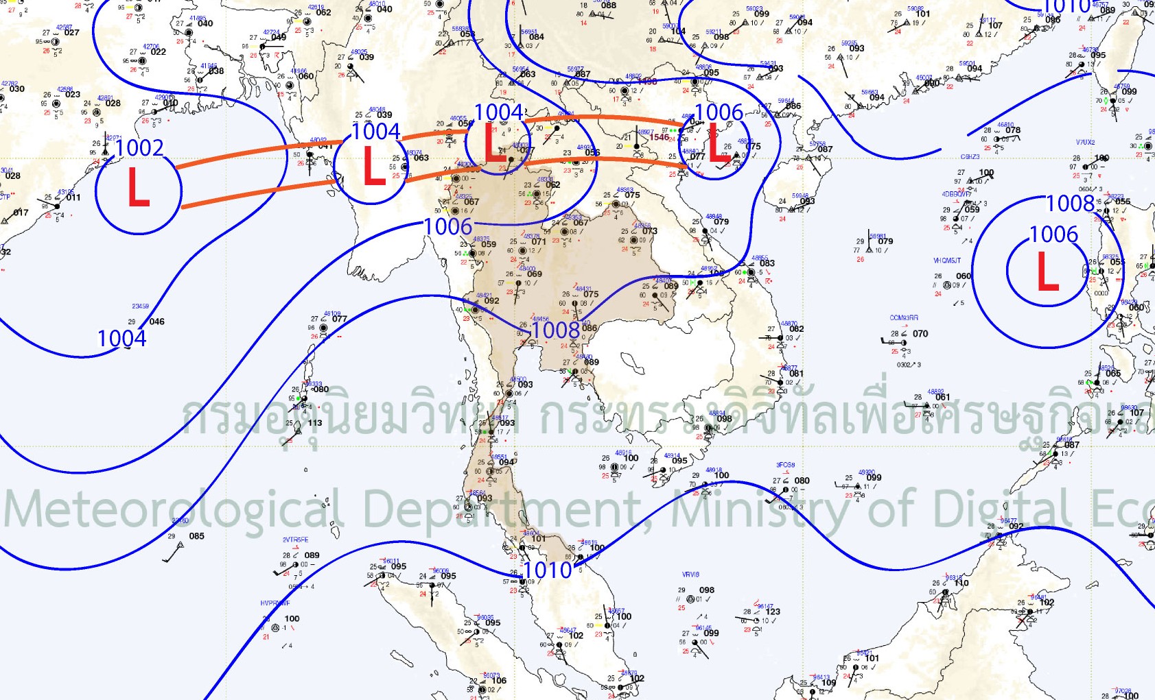
27/8/2025 00UTC
28/8/2025 00UTC
29/8/2025 00UTC
30/8/2025 00UTC
31/8/2025 00UTC
1/9/2025 00UTC
ปริมาณฝน
ช่วงปลายเดือนสิงหาคมถึงต้นเดือนกันยายน 2568 มีฝนตกหนักเกิดขึ้นในหลายพื้นที่ของประเทศไทยทั้งจากอิทธิพลของพายุ ร่องมรสุมที่พาดผ่านตอนบนของประเทศ รวมถึงลมมรสุมตะวันตกเฉียงใต้ที่พัดปกคลุมทะเลอันดามัน ประเทศไทยและอ่าวไทยอย่างต่อเนื่อง โดยแบ่งช่วงที่เกิดฝนตกหนัก ดังนี้
1) ช่วงวันที่ 21-24 สิงหาคม 2568 ร่องมรสุมที่พาดผ่านภาคเหนือและภาคตะวันออกเฉียงเหนือรวมทั้งมรสุมตะวันตกเฉียงใต้ ส่งผลทำให้ประเทศไทยมีฝนตกหนักถึงหนักมากเกิดขึ้นกระจายตัวในทุกภาคของประเทศ
2) ช่วงวันที่ 25-27 สิงหาคม 2568 อิทธิพลจากพายุไต้ฝุ่น “คาจิกิ” (KAJIKI) รวมถึงร่องมรสุมที่พาดผ่านภาคเหนือและภาคตะวันออกเฉียงเหนือของไทยเข้าสู่บริเวณที่เกิดพายุ ได้เริ่มส่งผลทำให้มีฝนตกมากขึ้นในบางพื้นที่ของภาคเหนือและภาคตะวันออกเฉียงเหนือในวันที่ 25 สิงหาคม 2568 และทำให้มีฝนตกหนักมากเกิดขึ้นในหลายพื้นที่ของภาคเหนือในช่วงวันที่ 26-27 สิงหาคม 2568
3) ช่วงวันที่ 30-31 สิงหาคม 2568 พายุโซนร้อน “หนองฟ้า” (NONGFA) รวมถึงร่องมรสุมที่พาดผ่านภาคเหนือและภาคตะวันออกเฉียงเหนือของไทยเข้าสู่บริเวณที่เกิดพายุ ส่งผลทำให้มีฝนตกหนักถึงหนักมากเกิดขึ้นเป็นบริเวณกว้างในพื้นที่ตอนบนของภาคตะวันออกเฉียงเหนือและพื้นที่ตอนล่างของภาคเหนือของไทย
4) ช่วงวันที่ 29 สิงหาคม 2568 ถึงช่วงต้นเดือนกันยายน 268 เกิดฝนตกหนักจากอิทธิพลของพายุที่ทำให้มรสุมตะวันตกเฉียงใต้มีกำลังแรงขึ้น ทำให้ด้านรับลมของประเทศทั้งภาคตะวันออก และด้านตะวันตกของภาคใต้มีฝนตกหนักถึงหนักมากเกิดขึ้นกระจายตัวในหลายพื้นที่
ทั้งนี้ ภาคเหนือและภาคตะวันออกเฉียงเหนือที่ได้รับผลกระทบโดยตรง มีจังหวัดที่เกิดฝนตกหนักมาก (ปริมาณฝนเกิน 90 มิลลิเมตรต่อวัน) ประกอบด้วย
• ภาคเหนือ 12 จังหวัด ได้แก่ เชียงใหม่ เชียงราย อุตรดิตถ์ สุโขทัย น่าน แพร่ พิษณุโลก เพชรบูรณ์ ลำปาง กำแพงเพชร ตาก ลำพูน
• ภาคตะวันออกเฉียงเหนือ 13 จังหวัด ได้แก่ ชัยภูมิ บุรีรัมย์ อำนาจเจริญ อุบลราชธานี กาฬสินธุ์ นครพนม มุกดาหาร หนองคาย เลย ขอนแก่น สกลนคร หนองบัวลำภู นครราชสีมา
โดยที่สถานีบ้านดอยปุย ต.สุเทพ อ.เมืองเชียงใหม่ จ.เชียงใหม่ มีปริมาณฝนสูงสุดถึง 240 มิลลิเมตร ในวันที่ 8 กันยายน 2568 รองลงมาคือที่สถานีบ้านโป่งตะแบก ต.พุทธบาท อ.ชนแดน จ.เพชรบูรณ์ ปริมาณฝนสะสม 217 มิลลิเมตร ในวันที่ 27 สิงหาคม 2568 สำหรับปริมาณฝนสะสม 7 วัน (ช่วงวันที่ 25-31 สิงหาคม 2568) ที่สถานีบ้านโป่งตะแบก มีปริมาณฝนมากที่สุดเช่นกัน โดยมีปริมาณฝนสะสม 661.5 มิลลิเมตร รองลงมาคือที่สถานีบ้านท่าข้าม ต.แม่ทา อ.แม่ออน จ.เชียงใหม่ ปริมาณฝนสะสม 446.5 มิลลิเมตร
Rainfall
From late August to early September 2025, heavy rain occurred in several areas of Thailand caused by the combined influence of storm, monsoon troughs lay across the upper part of the country, and the southwest monsoon that persistently prevailed over the Andaman Sea, Thailand, and the Gulf of Thailand. The periods of heavy rain can be divided as follows:
1) During 21-24 August 2025: the monsoon troughs lay across the North and the Northeast, accompanied by the southwest monsoon resulted in heavy to very heavy rain scattered across all regions of the country.
2) During 25-27 August 2025: the influence of Typhoon “KAJIKI” together with the monsoon trough extending across the North and the Northeast of Thailand toward this storm started to cause increased rainfall in some areas of the North and the Northeast on 25 August 2025. Subsequently, it caused heavy rain in several areas in the North during 26-27 August 2025
3) During 30-31 August 2025: Tropical Storm “NONGFA” along with the monsoon trough extending across the North and the Northeast of Thailand into the storm area. It caused heavy to very heavy rain in a wide area of upper northeastern and lower northeastern regions of Thailand.
4) From 29 August to early September 2025: heavy rain caused by the influence of storm strengthened the monsoon trough. It resulted in the windward side of the country, combining the East and the west side of the South facing heavy to very heavy rain spread in many areas.
However, the North and the Northeast, which were directly affected, faced very heavy rain with daily rainfall more than 90 millimeters per day including the following provinces:
• Northern Region (12 provinces): Chiang Mai, Chiang Rai, Uttaradit, Sukhothai, Nan, Phrae, Phitsanulok, Phetchabun, Lampang, Kamphaeng Phet, Tak, and Lamphun.
• Northeastern Region (13 provinces): Chaiyaphum, Buri Ram, Amnat Charoen, Ubon Ratchathani, Kalasin, Nakhon Phanom, Mukdahan, Nong Khai, Loei, Khon Kaen, Sakon Nakhon, Nong Bua Lamphu, and Nakhon Ratchasima.
At Ban Doi Pui Station, Suthep Subdistrict, Mueang Chiang Mai District, Chiang Mai Province, the maximum daily rainfall reached 240 millimeters on 8 September 2025. The second highest was recorded at Ban Pong Tabaek Station, Phutthabat Subdistrict, Chon Daen District, Phetchabun Province, with 217 millimeters on 27 August 2025. For the 7-day accumulated rainfall (25-31 August 2025), Ban Pong Tabaek Station also recorded the highest total, with 661.5 millimeters, followed by Ban Tha Kham Station, Mae Tha Subdistrict, Mae On District, Chiang Mai Province, which recorded 446.5 millimeters.
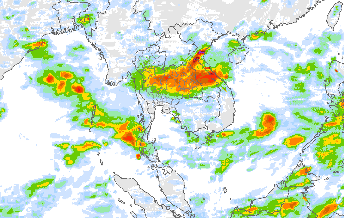
Maps of rainfall caused by the influence of Typhoon "KAJIKI" during 25-27 August 2025
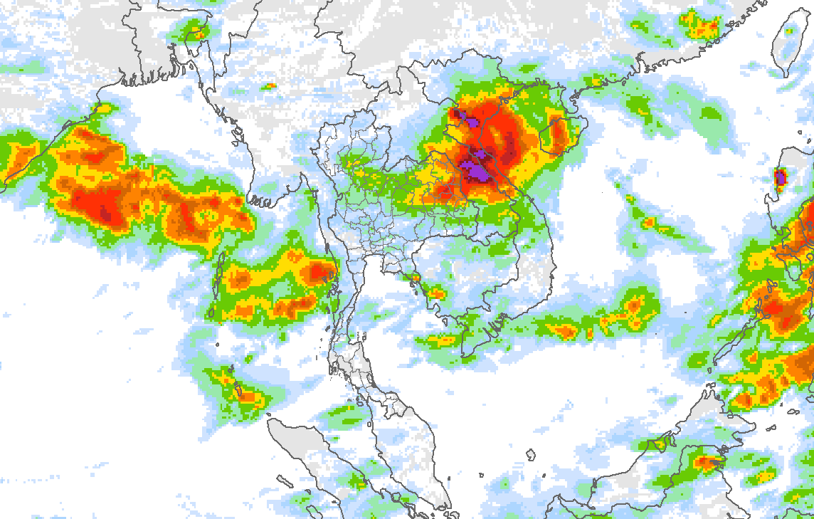
25/8/2025
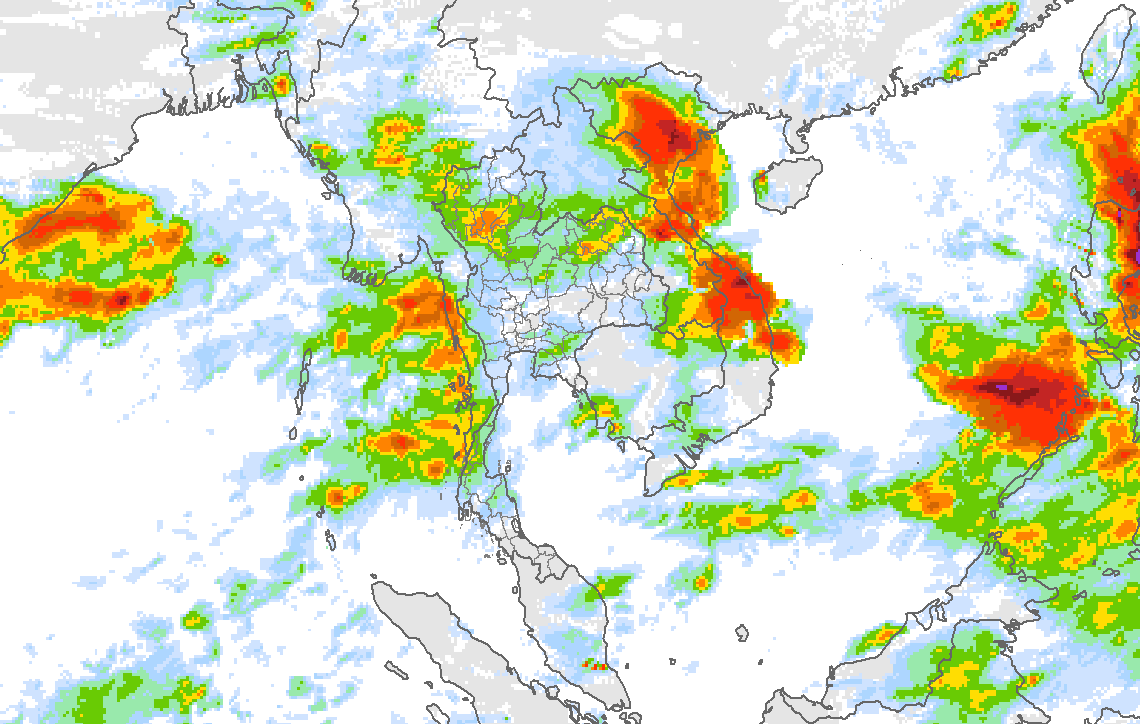
26/8/2025
27/8/2025
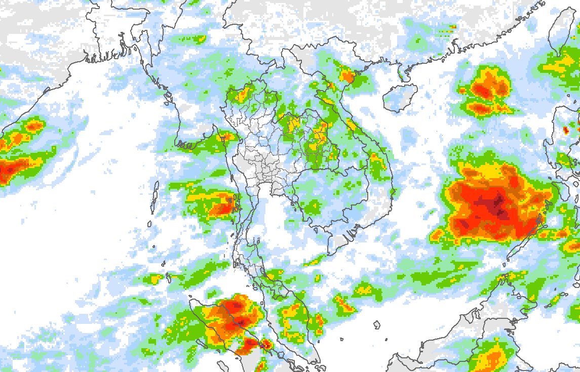
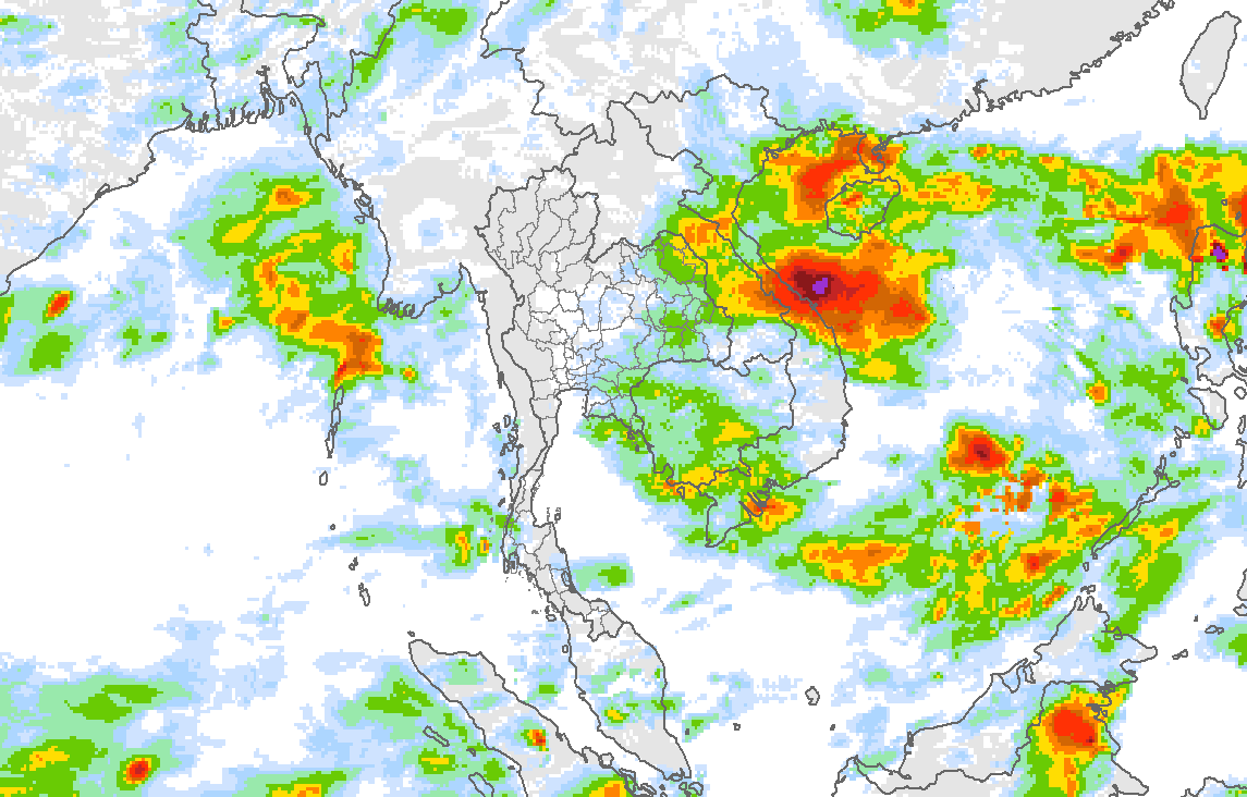
แผนภาพแสดงกลุ่มฝนจากอิทธิพลของพายุโซนร้อน "หนองฟ้า" ในช่วงวันที่ 29-31 สิงหาคม 2568
Maps of Rainfall caused by the influence of Tropical Storm "NONGFA" during 29-31 August 2025
29/8/2025
30/8/2025
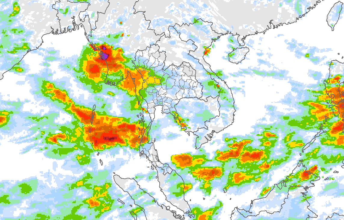
31/8/2025
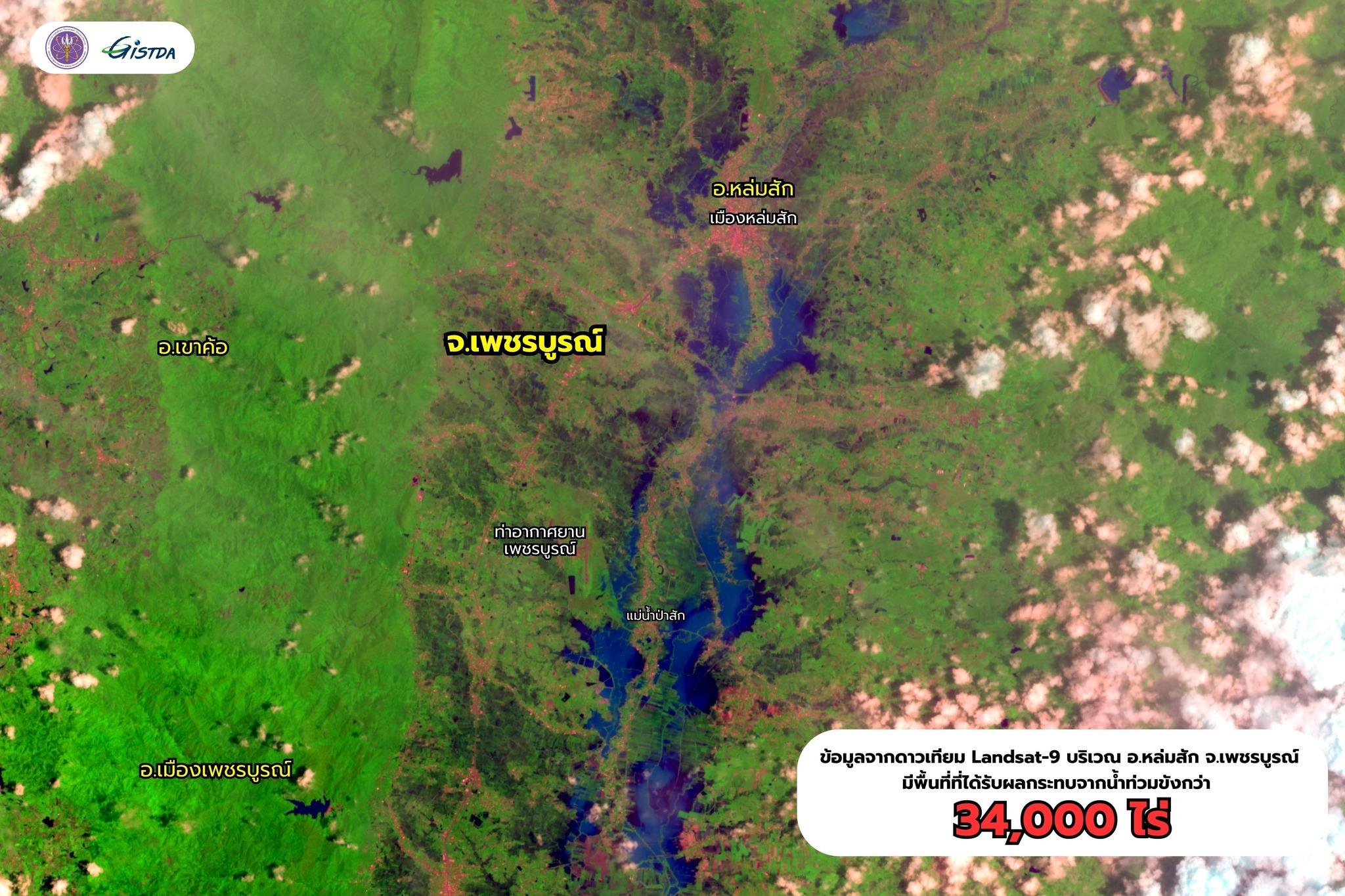
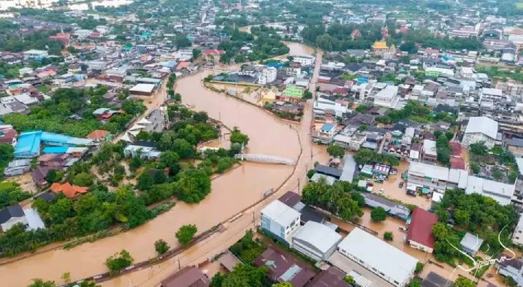
พื้นที่น้ำท่วมจากการวิเคราะห์ภาพถ่ายดาวเทียม (วิเคราะห์โดยสำนักงานพัฒนา เทคโนโลยีอวกาศและภูมิสารสนเทศ, สทอภ.)
จากการวิเคราะห์ภาพถ่ายดาวเทียมในช่วงวันที่ 23 สิงหาคม ถึง 8 กันยายน 2568 ซึ่งเป็นช่วงที่ประเทศไทยได้รับอิทธิพลจากทั้งพายุไต้ฝุ่น “คาจิกิ” และพายุโซนร้อน “หนองฟ้า” ดาวเทียมตรวจพบพื้นที่ถูกน้ำท่วมถึง 1.77 ล้านไร่ ใน 31 จังหวัด ประกอบด้วย
1) ภาคเหนือ 11 จังหวัด ได้แก่ พิษณุโลก สุโขทัย พิจิตร เพชรบูรณ์ เชียงราย อุตรดิตถ์ พะเยา น่าน ตาก แพร่ เชียงใหม่
2) ภาคตะวันออกเฉียงเหนือ 17 จังหวัด ได้แก่ นครพนม สกลนคร อุดรธานี หนองบัวลำภู ร้อยเอ็ด หนองคาย กาฬสินธุ์ ยโสธร ขอนแก่น อำนาจเจริญ บึงกาฬ อุบลราชธานี ชัยภูมิ มุกดาหาร มหาสารคาม เลย ศรีสะเกษ
3) ภาคกลาง 3 จังหวัด ได้แก่ นครสวรรค์ พระนครศรีอยุธยา อ่างทอง
โดยที่จังหวัดพิษณุโลกมีพื้นที่ถูกน้ำท่วมมากที่สุด 227,736 ไร่ รองลงมาคือจังหวัดสุโขทัยและพิจิตร ที่มีพื้นที่ถูกน้ำท่วม 214,510 และ 204,766 ไร่ ตามลำดับ
Flooded Areas Identified by Satellite Imagery Analysis (Reported by the Geo-Informatics and Space Technology Development Agency, GISTDA)
From the analysis of satellite imagery during 23 August to 8 September 2025, when Thailand was under the influence of both Typhoon “KAJIKI” and Tropical Storm “NONGFA”. Satellite detected flooding area of 1.77 million rai across 31 provinces, including:
1) Northern Region (11 provinces): Phitsanulok, Sukhothai, Phichit, Phetchabun, Chiang Rai, Uttaradit, Phayao, Nan, Tak, Phrae, and Chiang Mai.
2) Northeastern Region (17 provinces): Nakhon Phanom, Sakon Nakhon, Udon Thani, Nong Bua Lamphu, Roi Et, Nong Khai, Kalasin, Yasothon, Khon Kaen, Amnat Charoen, Bueng Kan, Ubon Ratchathani, Chaiyaphum, Mukdahan, Maha Sarakham, Loei, and Si Sa Ket.
3) Central Region (3 provinces): Nakhon Sawan, Phra Nakhon Si Ayutthaya, and Ang Thong.
Phitsanulok Province experienced the largest flooded area, covering 227,736 rai, followed by Sukhothai and Phichit Provinces, with 214,510 rai and 204,766 rai of flooded area, respectively.
Photo of flood area from Landsat-9 satellite on 4 September 2025 in Lomsak District, Petchabun Province
ความเสียหาย
(รายงานโดยกรมป้องกันและบรรเทา สาธารณภัย, ปภ.)
กรมป้องกันและบรรเทาสาธารณภัยได้รายงานความเสียหายจากอุทกภัย เมื่อวันที่ 1 กันยายน 2568 เวลา 18.00 น. ประกอบด้วย
1.ความเสียหายจากอิทธิพลของพายุไต้ฝุ่น “คาจิกิ”
พื้นที่ได้รับผลกระทบ: เกิดอุทกภัยและดินสไลด์ใน 14 จังหวัด ประกอบด้วย เชียงราย พะเยา น่าน แพร่ ลำปาง ลำพูน เชียงใหม่ แม่ฮ่องสอน เพชรบูรณ์ อุตรดิตถ์ สุโขทัย พิษณุโลก เลย นครพนม รวม 40 อำเภอ 114 ตำบล 377 หมู่บ้าน
ประชาชนได้รับผลกระทบ: 9,531 ครัวเรือน 40,224 คน
ผู้เสียชีวิต: 10 ราย ประกอบด้วย ที่จังหวัดเชียงใหม่ 8 ราย สาเหตุดินสไลด์ ที่จังหวัดแม่ฮ่องสอน 2 ราย สาเหตุจมน้ำ
ผู้ได้รับบาดเจ็บ: 15 ราย ที่จังหวัดเชียงใหม่ สาเหตุดินสไลด์
ผู้สูญหาย: 3 ราย ที่จังหวัดเชียงใหม่ 2 ราย สาเหตุดินสไลด์ จังหวัดแม่ฮ่องสอน 1 ราย สาเหตุน้ำพัดพา
ณ วันที่รายงาน ยังคงมีสถานการณ์และผลกระทบเกิดขึ้น ดังนี้
พื้นที่ได้รับผลกระทบ: 4 จังหวัด ได้แก่ เชียงใหม่ แม่ฮ่องสอน สุโขทัย พิษณุโลก รวม 10 อำเภอ 27 ตำบล 104 หมู่บ้าน
ประชาชนได้รับผลกระทบ: 2,979 ครัวเรือน 11,875 คน
2.ความเสียหายจากอิทธิพลพายุโซนร้อน “หนองฟ้า”
พื้นที่ได้รับผลกระทบ: เกิดสถานการณ์อุทกภัยในพื้นที่ 10 จังหวัด ได้แก่ ลำปาง ลำพูน อุตรดิตถ์ เพชรบูรณ์ กาฬสินธุ์ หนองบัวลำภู ขอนแก่น ภูเก็ต ระนอง ชุมพร รวม 29 อำเภอ 85 ตำบล 264 หมู่บ้าน
ประชาชนได้รับผลกระทบ: 9,363 ครัวเรือน 34,173 คน
ผู้ได้รับบาดเจ็บ: ไม่มี
ผู้เสียชีวิต: ไม่มี
ณ วันที่รายงานยังคงมีสถานการณ์และผลกระทบเกิดขึ้น ดังนี้
พื้นที่ได้รับผลกระทบ: 9 จังหวัด ประกอบด้วย ลำปาง ลำพูน อุตรดิตถ์ เพชรบูรณ์ กาฬสินธุ์ หนองบัวลำภู ขอนแก่น ระนอง ชุมพร รวม 27 อำเภอ 83 ตำบล 262 หมู่บ้าน
ประชาชนได้รับผลกระทบ: 9,363 ครัวเรือน 34,173 คน
Damage Assessment
(Reported by the Department of Disaster Prevention and Mitigation, DDPM)
DDPM reported the damage from flooding on 1 September 2025 at 6:00 p.m. as below:
1) Damages from Typhoon “KAJIKI”
Affected areas: floods and landslides occurred in 14 provinces, namely Chiang Rai, Phayao, Nan, Phrae, Lampang, Lamphun, Chiang Mai, Mae Hong Son, Phetchabun, Uttaradit, Sukhothai, Phitsanulok, Loei, and Nakhon Phanom covering 40 districts, 114 subdistricts, and 377 villages.
People affected: 9,531 households, totaling 40,224 people
Fatalities: 10 deaths, including 8 in Chiang Mai (caused by landslides) 2 in Mae Hong Son (drowning)
Injuries: 15 people in Chiang Mai (caused by landslides)
Missing people: 3 people, including 2 in Chiang Mai (landslides) 1 in Mae Hong Son (swept away by floodwaters)
As of the reporting date, the flooding continued in the following areas:
Affected area: 4 provinces including Chiang Mai, Mae Hong Son, Sukhothai, and Phitsanulok with totaling 10 districts, 27 subdistricts, and 104 villages
People Affected: 2,979 households and 11,875 people
2. Damages from Tropical Storm “NONGFA”
Affected areas: flooding occurred in 10 provinces, namely Lampang, Lamphun, Uttaradit, Phetchabun, Kalasin, Nong Bua Lamphu, Khon Kaen, Phuket, Ranong, and Chumphon covering 29 districts, 85 subdistricts, and 264 villages.
People affected: 9,363 households, totaling 34,173 persons
Injuries: None
Fatalities: None
As of the reporting date, the flooding continued in the following areas:
Affected area: 9 provinces including Lampang, Lamphun, Uttaradit, Phetchabun, Kalasin, Nong Bua Lamphu, Khon Kaen, Ranong, and Chumphon with totaling 27 districts, 83 subdistricts, and 262 villages
People affected: 9,363 households and 34,173 people
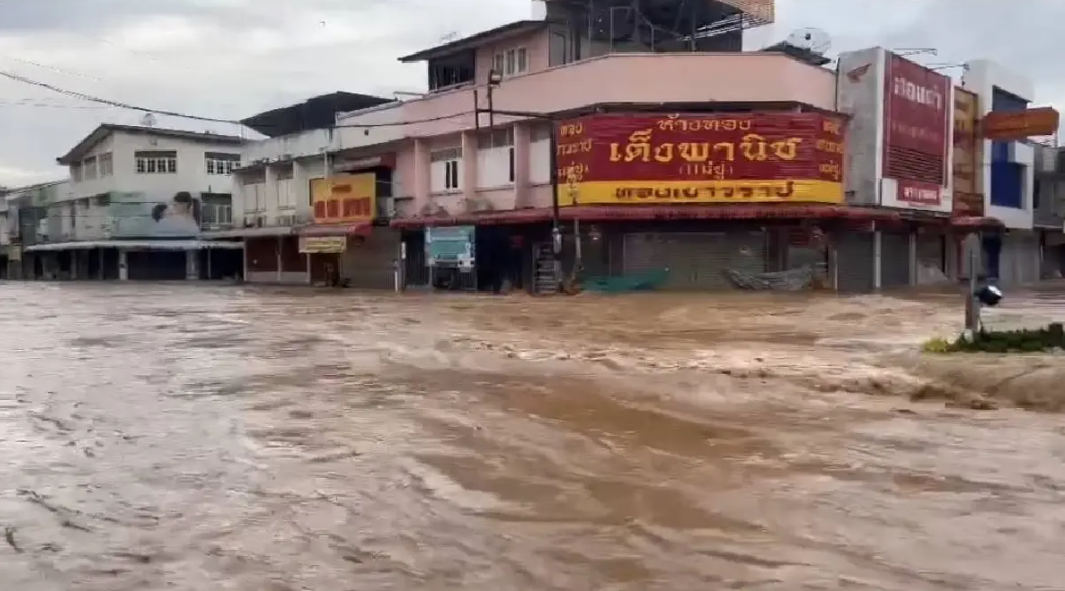
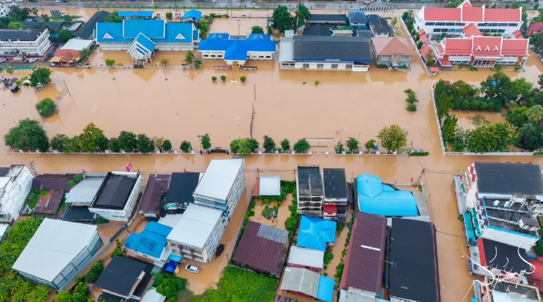
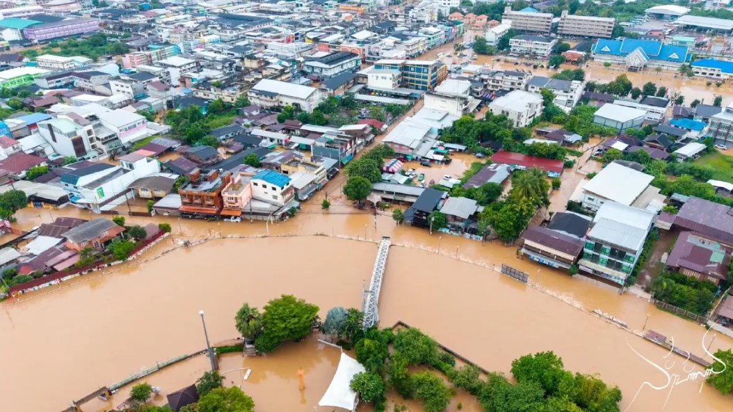
Photos of flood event in Lomsak and Nong Phai districts, Petchabun Province on 1 September 2025
ผลกระทบที่เกิดขึ้นกับเขื่อนขนาดใหญ่
ฝนตกหนักที่เกิดขึ้นส่งผลทำให้เขื่อนขนาดใหญ่มีน้ำไหลลงเขื่อนเพิ่มมากขึ้น โดยช่วงวันที่ 26 สิงหาคม ถึง 1 กันยายน 2568 ภาคเหนือมีน้ำไหลลงเขื่อนรวมกัน 1,488 ล้านลูกบาศก์เมตร ส่วนภาคตะวันออกเฉียงเหนือ 577 ล้านลูกบาศก์เมตร ทั้งนี้ เขื่อนที่มีน้ำไหลลงสะสมเกิน 100 ล้าน ลูกบาศก์เมตร ประกอบด้วย
• เขื่อนภูมิพล 597 ล้านลูกบาศก์เมตร
• เขื่อนสิริกิติ์ 594 ล้านลูกบาศก์เมตร
• เขื่อนวชิราลงกรณ 319 ล้านลูกบาศก์เมตร
• เขื่อนลำปาว 225 ล้านลูกบาศก์เมตร
• เขื่อนอุบลรัตน์ 171 ล้านลูกบาศก์เมตร
• เขื่อนศรีนครินทร์ 166 ล้านลูกบาศก์เมตร
• เขื่อนแควน้อยบำรุงแดน 115 ล้านลูกบาศก์เมตร
ทั้งนี้ก่อนเกิดเหตุการณ์ (วันที่ 22 สิงหาคม 2568) เขื่อนขนาดใหญ่ทั้งประเทศมีปริมาณน้ำกักเก็บรวมกัน 47,852 ล้านลูกบาศก์เมตร หรือ 67.47% ของความจุเขื่อน ซึ่งอยู่ในเกณฑ์น้ำปานกลาง แต่หลังจากเกิดเหตุการณ์พายุไต้ฝุ่น “คาจิกิ” และพายุโซนร้อน “หนองฟ้า” ปริมาณน้ำกักเก็บเพิ่มขึ้นเป็น 53,196 ล้านลูกบาศก์เมตร หรือ 75% ของความจุเขื่อน ยังคงอยู่ในเกณฑ์น้ำปานกลาง แต่เกิดน้ำล้นที่เขื่อนแม่มอก จ.ลำปาง รวมทั้งมีเขื่อนที่มีปริมาณน้ำกักเก็บอยู่ในเกณฑ์น้ำมากเพิ่มขึ้นเป็น 4 เขื่อน คือ เขื่อนห้วยหลวง เขื่อนน้ำอูน เขื่อนสิริกิติ์ และเขื่อนบางพระ จากเดิมที่มีเขื่อนสิริกิติ์เพียงเขื่อนเดียว
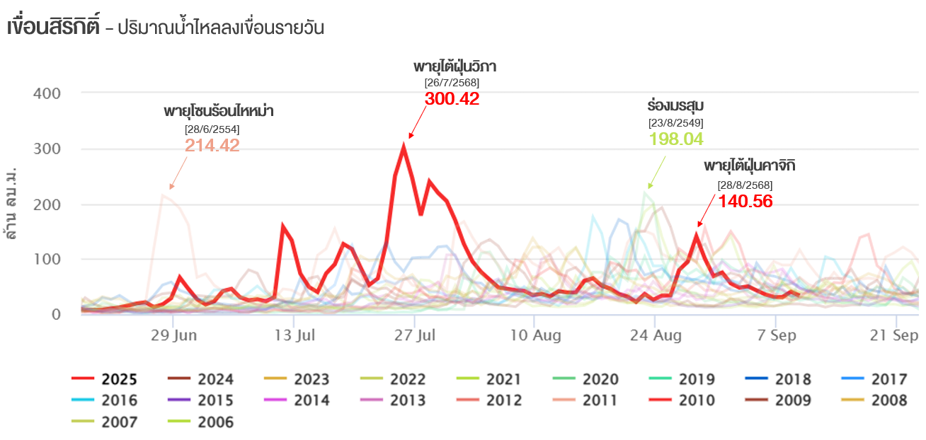
โดยในช่วงที่เขื่อนสิริกิติ์ได้รับผลกระทบจากพายุไต้ฝุ่น “คาจิกิ” และพายุโซนร้อน “หนองฟ้า” ระยะเวลา 7 วัน (ช่วงวันที่ 26 สิงหาคม ถึง 1 กันยายน 2568) มีปริมาณน้ำไหลลงเขื่อนเพียง 594 ล้านลูกบาศก์เมตรเท่านั้น โดยมีปริมาณน้ำไหลลงเขื่อนรายวันสูงสุด 140.56 ล้านลูกบาศก์เมตร ในวันที่ 28 สิงหาคม 2568 ซึ่งน้อยกว่าช่วงที่ได้รับผลกระทบจากพายุวิภาอยู่ค่อนข้างมาก ที่มีปริมาณน้ำไหลลงเขื่อนรายวันสูงสุดถึง 300.42 ล้านลูกบาศก์เมตร ซึ่งเกิดในช่วงเวลาเพียง 5 วัน แต่มีน้ำไหลลงเขื่อนสะสมถึง 122 ล้านลูกบาศก์เมตร
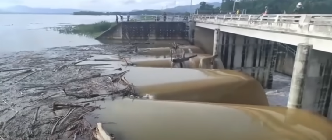
สำหรับเขื่อนแม่มอก มีปริมาณน้ำไหลลงเขื่อนมากถึง 36.34 ล้านลูกบาศก์เมตร ในวันที่ 1 กันยายน 2568 ซึ่งทำให้ปริมาณน้ำกักเก็บในเขื่อนเพิ่มขึ้นอย่างรวดเร็วมาก และเริ่มเกิดสถานการณ์น้ำล้นเขื่อนตั้งแต่วันที่ 2 กันยายน 2568 ต่อเนื่องไปจนถึงต้นเดือนตุลาคม 2568 ซึ่งเป็นสถานการณ์น้ำล้นเขื่อนที่เกิดขึ้นเร็วที่สุดเมื่อเทียบกับข้อมูลในอดีตตั้งแต่มีการสร้างเขื่อน
Impact on Major Dams
The heavy rainfall also resulted in a significant increase in inflow water to major dams. During 26 August to 1 September 2025, the North recorded a total inflow water of 1,488 million cubic meters (mcm), while the Northeast received 577 mcm.
Dams with cumulative inflow exceeding 100 mcm included:
• Bhumibol Dam: 597 mcm
• Sirikit Dam: 594 mcm
• Vajiralongkorn Dam: 319 mcm
• Lam Pao Dam: 225 mcm
• Ubolratana Dam: 171 mcm
• Sri Nakarin Dam: 166 mcm
• Kwae Noi Bamrung Dan Dam: 115 mcm
Before the event (as of 22 August 2025), the total water storage in all large dams nationwide was 47,852 mcm, or 67.47% of total capacity, which was considered at a moderate level.
After the impact of Typhoon “KAJIKI” and Tropical Storm “NONGFA” total water storage increased to 53,196 mcm, or 75% of capacity, which remained within the moderate range. However, overflow was observed at Mae Mok Dam in Lampang Province, and the number of dams with high water storage levels rose to four (Huai Luang Dam, Nam Un Dam, Sirikit Dam, and Bang Phra Dam) up from only one (Sirikit Dam) before the event.
During the period when Sirikit Dam was affected by Typhoon “KAJIKI” and Tropical Storm “NONGFA”, over seven days (26 August – 1 September 2025), the total water flowed into the dam was only 594 mcm. The maximum daily inflow reached 140.56 mcm on 28 August 2025. This was considerably lower than during the period influenced by Tropical Storm “WIPHA”, when the maximum daily inflow peaked at 300.42 mcm, occurring within just five days, yet producing a total accumulated inflow water of 1,122 mcm.
For Mae Mok Dam, the inflow water reached as high as 36.34 mcm on 1 September 2025, causing a rapid increase in the dam’s storage volume. The dam began to overflow on 2 September 2025, and the overflow condition persisted until early October 2025. This marked the earliest occurrence of overflow at the dam since its construction, based on historical records.
Graph of inflow volume of Sirikit Dam in Tha Pla District, Uttaradit Province
Graph of inflow volume of Mae Mok Dam in Thern District, Lampang Province
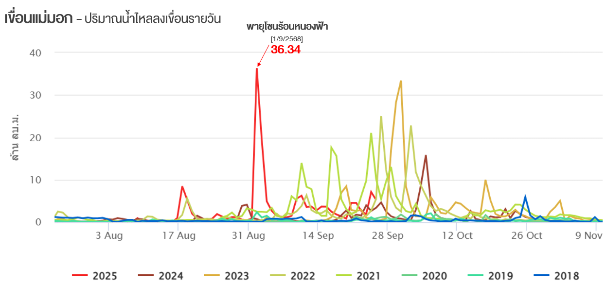
Photo of overflow water of Mae Mok Dam on 2 September 2025