Flooding in Mae Sai District, Chiang Rai Province (23-26 May 2025)
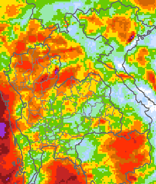
ช่วงปลายเดือนพฤษภาคม 2568 ลมมรสุมตะวันตกเฉียงใต้ที่พัดปกคลุมทะเลอันดามันและด้านตะวันตกของประเทศไทยมีกำลังแรง ประกอบกับมีลมตะวันออกเฉียงใต้และลมใต้พัดปกคลุมภาคเหนือตอนล่าง ภาคตะวันออกเฉียงเหนือ ภาคตะวันออก และภาคกลาง พร้อมทั้งมีร่องมรสุมพาดผ่านบริเวณภาคเหนือ ภาคกลาง ภาคตะวันออก และภาคใต้ตอนบน ส่งผลให้มีฝนตกหนักต่อเนื่องบริเวณภาคเหนือ ภาคตะวันออกเฉียงเหนือ ภาคกลาง และภาคใต้ฝั่ง
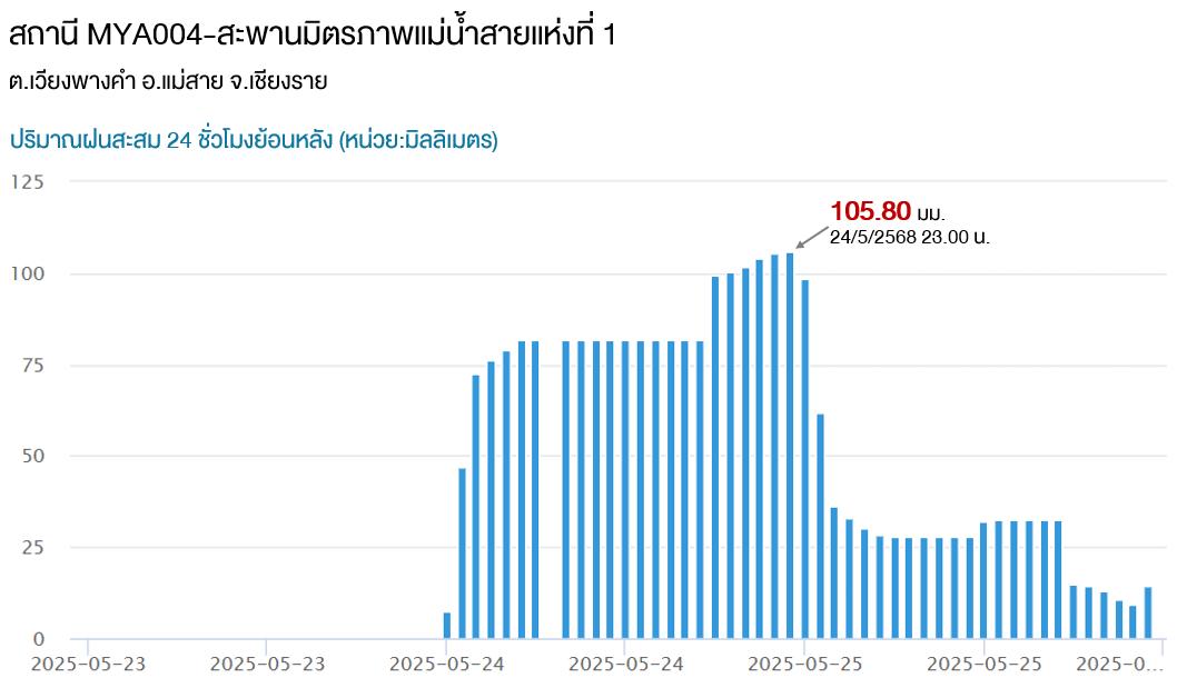
ตะวันตก สำหรับเหตุการณ์น้ำท่วมที่ อ.แม่สาย จ.เชียงราย มีสาเหตุหลักมาจากฝนตกหนักในพื้นที่ จ.เชียงราย รวมถึงพื้นที่ใกล้เคียงโดยเฉพาะอย่างยิ่งบริเวณชายแดนของประเทศเมียนมาที่มีพรมแดนติดกับจังหวัดเชียงราย ซึ่งได้เริ่มมีฝนตกหนักตั้งแต่กลางดึกของวันที่ 23 พฤษภาคมจนถึงช่วงเช้าของวันที่ 24 พฤษภาคม 2568 ทั้งนี้ สถานีตรวจวัดปริมาณฝนที่สะพานมิตรภาพแม่น้ำสายแห่งที่ 1 ตรวจวัดฝนสะสม 3 ชั่วโมง (ระหว่าง
เวลา 23.00 น. ของวันที่ 23 พฤษภาคม 2568 ถึงเวลา 02.00 น. ของวันที่ 24 พฤษภาคม 2568) ได้ 69.06 มิลลิเมตร และมีปริมาณฝนสะสมย้อนหลัง 24 ชั่วโมง ณ เวลา 23.00 น. ของวันที่ 24 พฤษภาคม 2568 สูงถึง 105.80 มิลลิเมตร ซึ่งอยู่ในเกณฑ์ฝนตกหนักมาก โดยมวลน้ำจากปริมาณฝนดังกล่าวได้ไหลผ่านแม่น้ำสาย-แม่น้ำรวกลงสู่พื้นที่ อ.แม่สาย ส่งผลให้เกิดน้ำล้นตลิ่งเข้าท่วมพื้นที่ริมน้ำหลายครั้ง
At the end of May 2025, the strong southwest monsoon prevailed over the Andaman Sea and western Thailand. This was accompanied by southeasterly and southerly winds covering the lower North, Northeast, East, and Central, along with a monsoon trough lying across the North, Central, East, and upper South. These weather conditions caused continuous heavy rain across the North, Northeast, Central, and
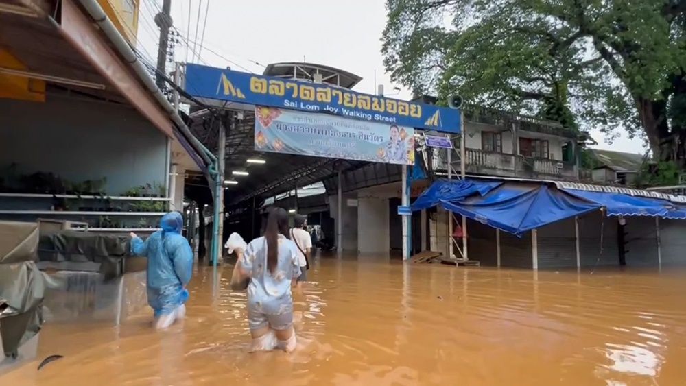
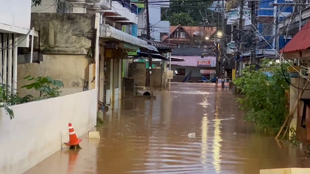
western coastal areas of the South. The flooding in Mae Sai District, Chiang Rai Province, was primarily caused by heavy rain in Chiang Rai Province and surrounding areas, particularly along the border areas of Myanmar adjacent to Chiang Rai Province. The heavy rain began during the night of May 23 until the morning of May 24, 2025. The rain gauge station at the First Mae Sai Friendship Bridge measured 3-hour
accumulated rainfall of 69.06 mm (from 11:00 PM on May 23 to 2:00 AM on May 24, 2025). The 24-hour accumulated rainfall as of 11:00 PM on May 24, 2025, reached 105.80 mm, classified as very heavy rain. Water from the heavy rain flowed through the Sai and Ruak rivers into Mae Sai District, resulting in riverbank overflow and flooding of riverside areas on multiple occasions.
ในช่วงวันที่ 22-27 พฤษภาคม 2568
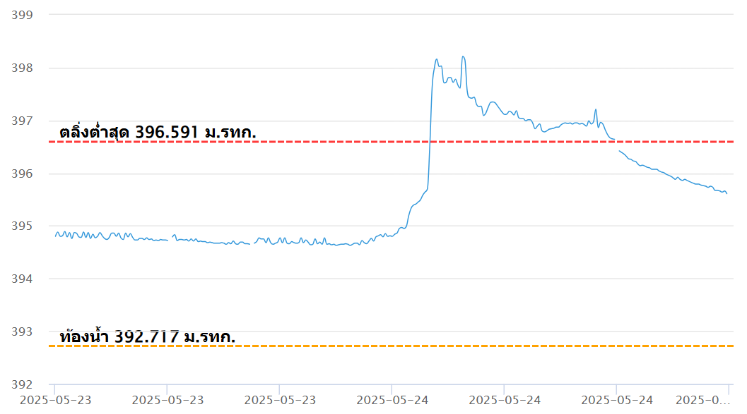
ฝนที่ตกหนักมากทำให้เกิดน้ำล้นตลิ่งบริเวณแม่น้ำสายไหลเข้าท่วมในหลายพื้นที่ของ อ.แม่สาย ทั้งนี้ระดับน้ำบริเวณสถานีตรวจวัดระดับน้ำที่สะพานมิตรภาพแม่น้ำสายแห่งที่ 1 ต.เวียงพางคำ อ.แม่สาย จ.เชียงราย เริ่มเพิ่มขึ้นตั้งแต่เวลา 22.30 น. ของวันที่ 23 พฤษภาคม 2568 และได้เพิ่มขึ้นอย่างต่อเนื่องจนเกิดการล้นตลิ่งเมื่อเวลาประมาณ 02.50 น. ของวันที่ 24
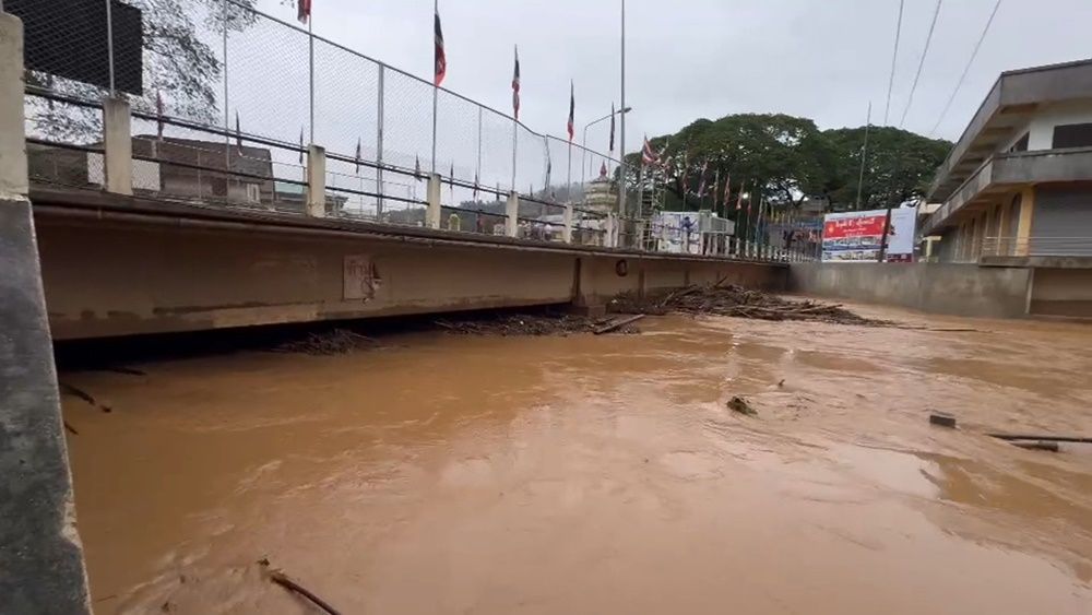
พฤษภาคม 2568 หลังจากนั้นระดับน้ำได้เพิ่มขึ้นอย่างต่อเนื่องจนไปถึงระดับสูงสุดที่ 398.16 ม.รทก. เมื่อเวลา 03.10 น. ของวันที่ 24 พฤษภาคม 2568 (สูงกว่าระดับตลิ่งประมาณ 1.57 เมตร) ต่อมาระดับน้ำได้ลดลงเล็กน้อยแล้วเพิ่มขึ้นไปสู่จุดสูงสุดอีกครั้งที่ระดับ 398.21 ม.รทก. เมื่อเวลา 05.00 น. ของวันที่ 24 พฤษภาคม 2568 หรือสูงกว่าระดับตลิ่ง 1.62 เมตร ซึ่งสูงกว่าครั้ง
แรกเล็กน้อย ทั้งนี้ระดับน้ำได้ลดต่ำกว่าระดับตลิ่งในเวลา 16.20 น. ของวันที่ 24 พฤษภาคม 2568 สำหรับบริเวณแม่น้ำรวกในจังหวัดท่าขี้เหล็ก ประเทศเมียนมา ซึ่งประกอบด้วย ที่สะพานอูทูนอ่อง-บ้านสบสาย บ้านดอยต่อคำ และบ้านโจนดาตา ในวันที่ 24 พฤษภาคม 2568 ระดับน้ำได้เพิ่มขึ้นค่อนข้างมากแต่ยังไม่ล้นตลิ่ง
The heavy rainfall caused the Sai River to overflow and flood many areas of Mae Sai District. The water level at the First Mae Sai Friendship Bridge monitoring station in Wiang Phang Kham Subdistrict, Mae Sai District, Chiang Rai Province began rising from 10:30 PM on May 23, 2025. Its continued to rise and overflow the riverbanks at around 2:50 AM on May 24, 2025.
Subsequently, it reached its peak at 398.16 meters above mean sea level (m msl) at 3:10 AM on May 24, 2025 - about 1.57 meters above the riverbank level. After that, the water level slightly dropped before rising again to reach a second peak of 398.21 m msl at 5:00 AM on May 24, 2025 (1.62 meters above the riverbank level), which was slightly higher than the first peak. The water
level eventually dropped below the riverbank level at 4:20 PM on May 24, 2025. Meanwhile, the water levels along the Ruak River in Tachileik Province, Myanmar, at the Utun Aung Bridge–Ban Sop Sai, Ban Doi Tokham, and Ban Jon Darta, also rose significantly on May 24, 2025, but did not overflow the riverbanks.
ต.เวียงพางคำ อ.แม่สาย จ.เชียงราย
กรมป้องกันและบรรเทาสาธารณภัยได้รายงานความเสียหายจากอุทกภัยเมื่อวันที่ 24 พฤษภาคม 2568 เวลา 18.00 น. โดยระบุว่าเมื่อวันที่ 23 พฤษภาคม 2568 เกิดฝนตกหนักทำให้เกิดน้ำท่วมและน้ำป่าไหล
หลากบริเวณจังหวัดเชียงราย ครอบคลุมพื้นที่ 2 อำเภอ 2 ตำบล 8 หมู่บ้าน ดังรายละเอียดต่อไปนี้
• หมู่ 1 2 7 และ 10 ของ ต.เวียงพางคำ อ.แม่สาย
• หมู่ 3 5 6 และ 9 ของ ต.โป่งแพร่ อ.แม่ลาว
โดยไม่มีผู้ได้รับบาดเจ็บและเสียชีวิต ณ วันที่รายงาน สถานการณ์ได้คลี่คลายลงแล้ว
The Department of Disaster Prevention and Mitigation (DDPM) reported flood damage at 6:00 PM on May 24, 2025, stating that heavy rain on May 23, 2025, caused flooding and flash floods in
Chiang Rai Province, subdistricts, and 8 villages as follows:
• Villages 1, 2, 7, and 10 in Wiang Phang Kham Subdistrict, Mae Sai District
• Villages 3, 5, 6, and 9 in Pong Phrae Subdistrict, Mae Lao District
No injuries or fatalities were reported as of the date of this report, and the situation had been resolved.